Difference between revisions of "Ruthvoes"
From Wikishire
(Created page with "{{Infobox town |name=Ruthvoes |cornish=Rudhfos |county=Cornwall |picture=Ruthvoes - geograph.org.uk - 221799.jpg |picture caption=Cottages in Ruthvoes village |os grid ref=SW9...") |
(No difference)
|
Latest revision as of 22:23, 26 September 2016
| Ruthvoes Cornish: Rudhfos | |
| Cornwall | |
|---|---|
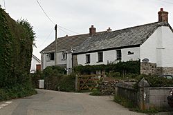
 Cottages in Ruthvoes village | |
| Location | |
| Grid reference: | SW925605 |
| Location: | 50°24’29"N, 4°55’21"W |
| Data | |
| Post town: | St Columb |
| Postcode: | TR9 |
| Local Government | |
| Council: | Cornwall |
Ruthvoes is a village in the midst part of Cornwall, in the parish of St Columb Major, about two miles south of St Columb Major itself and six and a half miles east of Newquay. Indian Queens is just to the south, across the A30 dual carriageway trunk road.
The village lies on the northwest edge of Goss Moor near the A30. The Par to Newquay branch railway line passes south of the settlement.
Ruthvoes was reputed as the location of the holy well of Saint Columba the virgin and, according to legend, is where she was beheaded.[1][2]
References
- ↑ Information on Ruthvoes from GENUKI
- ↑ St Columba Way Retrieved May 2010