Difference between revisions of "Playing Place"
From Wikishire
(Created page with "{{Infobox town |name=Playing Place |county=Cornwall |picture=Playing Place - geograph.org.uk - 149273.jpg |picture caption=Playing Place |os grid ref=SW811414 |latitude=50.232...") |
(No difference)
|
Latest revision as of 12:33, 20 September 2016
| Playing Place | |
| Cornwall | |
|---|---|
 Playing Place | |
| Location | |
| Grid reference: | SW811414 |
| Location: | 50°13’55"N, 5°4’16"W |
| Data | |
| Local Government | |
| Council: | Cornwall |
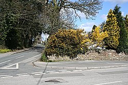
Playing Place is a village southwest of Truro in Cornwall. It is to the east of the A39 road.
The village appears to be named after a mediæval public space, known in Cornish as a Plen-an-gwary, used for plays, sports, and public events. The phrase Plen-an-gwary means "playing place". There is no clear remaining sign of such a space in the village however.