Albemarle, Falkland Islands: Difference between revisions
m RB moved page Port Albemarle to Albemarle, Falkland Islands |
No edit summary |
||
| Line 5: | Line 5: | ||
|latitude=-52.199697 | |latitude=-52.199697 | ||
|longitude=-60.503391 | |longitude=-60.503391 | ||
|constituency=Camp | |||
}} | }} | ||
'' | ''Albemarle''' is the southernmost settlement on [[West Falkland]], in the [[Falkland Islands]]. It is in the far south of the island, on the east side, at the southern end of [[Falkland Sound]]. The area round about Albemarle is considered to have some of the most beautiful scenery in the Falkland Islands. | ||
Owing to its large harbour, Albemarle became a successful sealing station, during the late 19th century, and the ruins of the buildings are still to be seen. It was enlarged during the period after the Second World War by the Colonial Development Company | The settlement is also known as '''Port Albemarle''', though the latter name refers more particularly to the sheltered sound between the main island and the [[Arch Islands]], which lie just offshore from Albemarle. | ||
Owing to its large harbour, Albemarle became a successful sealing station, during the late 19th century, and the ruins of the buildings are still to be seen. It was enlarged during the period after the Second World War by the Colonial Development Company, as was [[Ajax Bay]], and included its own power station, jetty, Nissen huts and such installations. These have all been abandoned, but there is still a sheep station here, run by Leon and Pam Berntsen. | |||
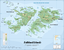
[[File:Falkland Islands topographic map-en.svg|thumb|250px|Map of the Falkland Islands showing Port Albemarle.]] | [[File:Falkland Islands topographic map-en.svg|thumb|250px|Map of the Falkland Islands showing Port Albemarle.]] | ||
==References== | ==References== | ||
{{reflist}} | {{reflist}} | ||
Latest revision as of 22:23, 5 August 2016
| Port Albemarle | |
| Falkland Islands | |
|---|---|
| Location | |
| Island: | West Falkland |
| Location: | 52°11’59"S, 60°30’12"W |
| Data | |
| Local Government | |
| Parliamentary constituency: |
Camp |
Albemarle' is the southernmost settlement on West Falkland, in the Falkland Islands. It is in the far south of the island, on the east side, at the southern end of Falkland Sound. The area round about Albemarle is considered to have some of the most beautiful scenery in the Falkland Islands.
The settlement is also known as Port Albemarle, though the latter name refers more particularly to the sheltered sound between the main island and the Arch Islands, which lie just offshore from Albemarle.
Owing to its large harbour, Albemarle became a successful sealing station, during the late 19th century, and the ruins of the buildings are still to be seen. It was enlarged during the period after the Second World War by the Colonial Development Company, as was Ajax Bay, and included its own power station, jetty, Nissen huts and such installations. These have all been abandoned, but there is still a sheep station here, run by Leon and Pam Berntsen.
