Staxigoe: Difference between revisions
Jump to navigation
Jump to search
No edit summary |
No edit summary |
||
| Line 2: | Line 2: | ||
|name=Staxigoe | |name=Staxigoe | ||
|county=Caithness | |county=Caithness | ||
|picture= | |picture=Staxigoe Harbour - geograph.org.uk - 931253.jpg | ||
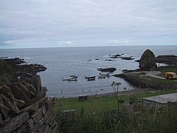
|picture caption= | |picture caption=Staxigoe Harbour | ||
|os grid ref=ND382523 | |os grid ref=ND382523 | ||
|latitude=58.45542 | |latitude=58.45542 | ||
Latest revision as of 21:28, 13 June 2016
| Staxigoe | |
| Caithness | |
|---|---|
 Staxigoe Harbour | |
| Location | |
| Grid reference: | ND382523 |
| Location: | 58°27’20"N, 3°3’36"W |
| Data | |
| Post town: | Wick |
| Postcode: | KW1 4 |
| Local Government | |
| Council: | Highland |
| Parliamentary constituency: |
Caithness, Sutherland and Easter Ross |
Staxigoe is a former fishing village, located two miles east of Wick on the north-eastern coast of Caithness. Its name derives from Norse words meaning "Inlet of the stack". The word "Geo" for an inlet is in common use in Shetland, though found on the coast of Caithness also.
Staxigoe was once the largest herring salting station in Europe, but its fishing industry went into decline with the construction of a larger port in central Wick.
Outside links
| ("Wikimedia Commons" has material about Staxigoe) |
- Staxigoe – Catihness.org
