Walwick: Difference between revisions
Jump to navigation
Jump to search
Created page with "{{Infobox town |name=Walwick |county=Northumberland |picture= |picture caption= |os grid ref=NY905705 |latitude=55.029 |longitude=-2.150 |population= |post town=Hexham |postco..." |
No edit summary |
||
| Line 2: | Line 2: | ||
|name=Walwick | |name=Walwick | ||
|county=Northumberland | |county=Northumberland | ||
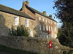
|picture= | |picture=House at Walwick - geograph.org.uk - 1066975.jpg | ||
|picture caption= | |picture caption=House at Walwick | ||
|os grid ref=NY905705 | |os grid ref=NY905705 | ||
|latitude=55.029 | |latitude=55.029 | ||
Latest revision as of 22:27, 10 March 2016
| Walwick | |
| Northumberland | |
|---|---|
 House at Walwick | |
| Location | |
| Grid reference: | NY905705 |
| Location: | 55°1’44"N, 2°9’-0"W |
| Data | |
| Post town: | Hexham |
| Postcode: | NE46 |
| Local Government | |
| Council: | Northumberland |
| Parliamentary constituency: |
Hexham |
Walwick is a village in Northumberland near Hadrian's Wall, from which it takes its name. Nearby villages include Humshaugh, Chollerford and Low Brunton.
Outside links
| ("Wikimedia Commons" has material about Walwick) |
References

This Northumberland article is a stub: help to improve Wikishire by building it up.
