Red Rice: Difference between revisions
No edit summary |
|||
| Line 19: | Line 19: | ||
*An old word 'rice', meaning shrubby twigs or withies (such as wild dogwood, which is abundant locally, and whose branches turn bright red in winter).<ref>Unpublished research by Veronica Stokes in 1961.</ref> | *An old word 'rice', meaning shrubby twigs or withies (such as wild dogwood, which is abundant locally, and whose branches turn bright red in winter).<ref>Unpublished research by Veronica Stokes in 1961.</ref> | ||
*The Anglo-Saxon term 'Rede Ric', meaning a council chamber.<ref | *The Anglo-Saxon term 'Rede Ric', meaning a council chamber.<ref>Harry Dexter White papers, Box 7, Princeton University Library.</ref> | ||
*The brick colour of clay loam, chalk and iron oxide from Sidbury.<ref>The Journal of the Royal Agricultural Society of England. Published 1861</ref> | *The brick colour of clay loam, chalk and iron oxide from Sidbury.<ref>The Journal of the Royal Agricultural Society of England. Published 1861</ref> | ||
Revision as of 21:22, 22 February 2016
| Red Rice | |
| Hampshire | |
|---|---|
 Red Rice House | |
| Location | |
| Grid reference: | SU338421 |
| Location: | 51°10’37"N, 1°31’4"W |
| Data | |
| Post town: | Andover |
| Postcode: | SP11 |
| Dialling code: | 01264 |
| Local Government | |
| Council: | Test Valley |
| Parliamentary constituency: |
North West Hampshire |
Red Rice is a hamlet in north-western Hampshire, sitting a little south-west of Andover.
The name of the place has been the subject of speculation. It may originate from:
- An old word 'rice', meaning shrubby twigs or withies (such as wild dogwood, which is abundant locally, and whose branches turn bright red in winter).[1]
- The Anglo-Saxon term 'Rede Ric', meaning a council chamber.[2]
- The brick colour of clay loam, chalk and iron oxide from Sidbury.[3]
History
In 986 it is recorded that the lands hereabouts were owned by the Abbey of Wherwell, when it was founded Queen Aelfrida, the widow of King Edgar.[4] This was before the hamlet appeared however, as far as can be said. The area is recorded in the Domesday Book, though not Red Rice itself.
Around the time of the dissolution of the Monasteries, the Abbey's lands were granted to Thomas West, Lord De La Warr.
Red Rice House and park
- Main article: Red Rice House
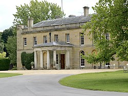
Red Rice House stands by the village: a fine house built in an early Georgian park. The house was probably built around 1740. The outside is faced with Clipsham stone. It has a slate roof and arched windows. There are 13 bays and a porte cochere of 4 Tuscan columns.
The stables areas include a clock tower and an arch of rubbed bricks. The park was extended by the diversion of a local road and the building has been extended.
William Burn re-modelled the house in the mid 19th century. More buildings were added when the site became a school in 1961.
The gate lodge and gatepiers are designated Grade II listed buildings.[5][6][7]
Pictures
-
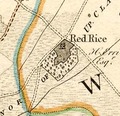
1759 map
-
1791 map
-
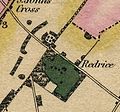
1826 map
-
Aerial view of Red Rice, circa 1960
Outside links
| ("Wikimedia Commons" has material about Red Rice) |
References
- ↑ Unpublished research by Veronica Stokes in 1961.
- ↑ Harry Dexter White papers, Box 7, Princeton University Library.
- ↑ The Journal of the Royal Agricultural Society of England. Published 1861
- ↑ "Rev Stephen Bachiler". Miner Descent. 16 May 2010. http://minerdescent.com/2010/05/16/rev-stephen-bachiler/. Retrieved 8 November 2012.
- ↑ National Heritage List 1230472: Red Rice
- ↑ http://www.parksandgardens.ac.uk/index2.php?option=com_parksandgardens&task=site&id=3836&preview=1&Itemid=292>
- ↑ Nikolaus Pevsner: The Buildings of England: Hampshire & The Isle of Wight, 1967 Penguin Books ISBN 978-0-300-09606-4


