Elwick, Northumberland: Difference between revisions
Jump to navigation
Jump to search
Created page with "{{Infobox town |name=Elwick |county=Northumberland |picture= |picture caption= |os grid ref=NU115369 |latitude=55.625562 |longitude=-1.818494 |postcode=NE70 |post town= |popul..." |
No edit summary |
||
| Line 2: | Line 2: | ||
|name=Elwick | |name=Elwick | ||
|county=Northumberland | |county=Northumberland | ||
|picture= | |picture=Farm Steading, Elwick - geograph.org.uk - 227066.jpg | ||
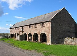
|picture caption= | |picture caption=Farm Steading at Elwick | ||
|os grid ref=NU115369 | |os grid ref=NU115369 | ||
|latitude=55.625562 | |latitude=55.625562 | ||
| Line 18: | Line 18: | ||
Elwick itself is not directly on the shore, though a short footpath leads out to the coastline, though not to any landing place. | Elwick itself is not directly on the shore, though a short footpath leads out to the coastline, though not to any landing place. | ||
==Outside links== | |||
{{commons}} | |||
Revision as of 22:46, 7 January 2016
| Elwick | |
| Northumberland | |
|---|---|
 Farm Steading at Elwick | |
| Location | |
| Grid reference: | NU115369 |
| Location: | 55°37’32"N, 1°49’7"W |
| Data | |
| Postcode: | NE70 |
| Local Government | |
| Council: | Northumberland |
| Parliamentary constituency: |
Berwick upon Tweed |
Elwick is a tiny hamlet in the north of Northumberland, overlooking the broad bay formed by the county's mainland coast and Holy Island to the north. The mudflats are broad here at low tide, and crossed by becks with such names as "Stinking Goat" and "Foulwork Burn".
Elwick itself is not directly on the shore, though a short footpath leads out to the coastline, though not to any landing place.
Outside links
| ("Wikimedia Commons" has material about Elwick, Northumberland) |
