Difference between revisions of "Thurning, Huntingdonshire"
From Wikishire
| Line 14: | Line 14: | ||
|constituency=Corby | |constituency=Corby | ||
}} | }} | ||
| − | '''Thurning''' is a village in [[Huntingdonshire]], in the northwest of the county by the border with [[Northamptonshire]]. It is about | + | '''Thurning''' is a village in [[Huntingdonshire]], in the northwest of the county by the border with [[Northamptonshire]]. It is about five and a half miles south-east of [[Oundle]] in the latter county. |
At the time of the 2001 census, the population of Thurning Civil Parish was just 93. | At the time of the 2001 census, the population of Thurning Civil Parish was just 93. | ||
Revision as of 16:54, 12 December 2015
| Thurning | |
| Huntingdonshire | |
|---|---|
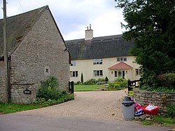
 The Old Rectory, Thurning | |
| Location | |
| Grid reference: | TL0882 |
| Location: | 52°25’47"N, 0°24’21"W |
| Data | |
| Population: | 93 |
| Post town: | Peterborough |
| Postcode: | PE8 |
| Dialling code: | 01832 |
| Local Government | |
| Council: | North Northamptonshire |
| Parliamentary constituency: |
Corby |
Thurning is a village in Huntingdonshire, in the northwest of the county by the border with Northamptonshire. It is about five and a half miles south-east of Oundle in the latter county.
At the time of the 2001 census, the population of Thurning Civil Parish was just 93.
Outside links
| ("Wikimedia Commons" has material about Thurning, Huntingdonshire) |