Ogre Hill: Difference between revisions
Jump to navigation
Jump to search
Created page with "{{Infobox hill |name=Ogre Hill |county=Northumberland |range=Cheviot Hills |picture=Quarry - geograph.org.uk - 907449.jpg |picture caption=Quarry on the side of Ogre Hill |he..." |
No edit summary |
||
| Line 10: | Line 10: | ||
|longitude=-2.35278 | |longitude=-2.35278 | ||
}} | }} | ||
'''Ogre Hill''' is a hill amongst the [[Cheviot Hills]], in [[Northumberland]], but just half a mile, if that, | '''Ogre Hill''' is a hill amongst the [[Cheviot Hills]], in [[Northumberland]], but just half a mile, if that, from the boundary of [[Roxburghshire]]. [[Ravens Knowe]] is immediately to the south. | ||
The summits of Ogre Hill and Ravens Knowe help to mark the western boundary here of the [[Otterburn Ranges]], the army's live firing training area. Nevertheless, the [[Pennine Way]] runs over the summit, up the ridge from Ravens Knowe. | The summits of Ogre Hill and Ravens Knowe help to mark the western boundary here of the [[Otterburn Ranges]], the army's live firing training area. Nevertheless, the [[Pennine Way]] runs over the summit, up the ridge from Ravens Knowe. | ||
The western slopes of the hill have in the past been quarried. | The western slopes of the hill have in the past been quarried. | ||
Latest revision as of 21:09, 2 September 2015
| Ogre Hill | |||
| Northumberland | |||
|---|---|---|---|
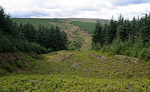
 Quarry on the side of Ogre Hill | |||
| Range: | Cheviot Hills | ||
| Summit: | 1,693 feet NT777069 55°21’20"N, 2°21’10"W | ||
Ogre Hill is a hill amongst the Cheviot Hills, in Northumberland, but just half a mile, if that, from the boundary of Roxburghshire. Ravens Knowe is immediately to the south.
The summits of Ogre Hill and Ravens Knowe help to mark the western boundary here of the Otterburn Ranges, the army's live firing training area. Nevertheless, the Pennine Way runs over the summit, up the ridge from Ravens Knowe.
The western slopes of the hill have in the past been quarried.