Abergwesyn: Difference between revisions
Created page with '{{Infobox town |name=Abergwesyn |county=Radnorshire |picture=Abergwesyn church - geograph.org.uk - 1221372.jpg |picture caption=Abergwesyn church |os grid ref=SN853525 |LG distri…' |
No edit summary |
||
| Line 1: | Line 1: | ||
{{Infobox town | {{Infobox town | ||
|name=Abergwesyn | |name=Abergwesyn | ||
|county= | |county=Brecknockshire | ||
|picture=Abergwesyn church - geograph.org.uk - 1221372.jpg | |picture=Abergwesyn church - geograph.org.uk - 1221372.jpg | ||
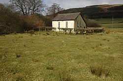
|picture caption=Abergwesyn church | |picture caption=Abergwesyn church | ||
|os grid ref=SN853525 | |os grid ref=SN853525 | ||
| longitude=-3.6773 | |||
| latitude=52.1588 | |||
| constituency=Brecon & Radnorshire | |||
|LG district=Powys | |LG district=Powys | ||
|post town=Llanwrtyd Wells | |||
|postcode=LD5 | |||
|dialling code=01591 | |||
}} | }} | ||
'''Abergwesyn''' is a village in [[ | '''Abergwesyn''' is a village in [[Brecknockshire]], at the mouth of the Abergwesyn valley and the confluence of the [[River Irfon]] and the [[River Gwesyn]]. It is a lonely place between the forests that rise up and coat the hills to either side. | ||
==Abergwestyn Commons== | ==Abergwestyn Commons== | ||
{{Main|Abergwesyn Common}} | {{Main|Abergwesyn Common}} | ||
The Abergwesyn Commons cover 16,500 acres and stretch for 12 miles between the Nant Irfon valley and Llanwrthwl. They are rich in archaeology, including Bronze Age ritual sites and deserted medieval villages. A National Trust project is focused on the preservation of the peatland. | The Abergwesyn Commons cover 16,500 acres and stretch for 12 miles between the Nant Irfon valley and [[Llanwrthwl]]. They are rich in archaeology, including Bronze Age ritual sites and deserted medieval villages. A [[National Trust for Places of Historic Interest or Natural Beauty|National Trust]] project is focused on the preservation of the peatland. | ||
==Parish church== | ==Parish church== | ||
Revision as of 15:18, 27 October 2014
| Abergwesyn | |
| Brecknockshire | |
|---|---|
 Abergwesyn church | |
| Location | |
| Grid reference: | SN853525 |
| Location: | 52°9’32"N, 3°40’38"W |
| Data | |
| Post town: | Llanwrtyd Wells |
| Postcode: | LD5 |
| Dialling code: | 01591 |
| Local Government | |
| Council: | Powys |
| Parliamentary constituency: |
Brecon & Radnorshire |
Abergwesyn is a village in Brecknockshire, at the mouth of the Abergwesyn valley and the confluence of the River Irfon and the River Gwesyn. It is a lonely place between the forests that rise up and coat the hills to either side.
Abergwestyn Commons
- Main article: Abergwesyn Common
The Abergwesyn Commons cover 16,500 acres and stretch for 12 miles between the Nant Irfon valley and Llanwrthwl. They are rich in archaeology, including Bronze Age ritual sites and deserted medieval villages. A National Trust project is focused on the preservation of the peatland.
Parish church
In 1740 the curate in the parishes of Llanwrtyd, Llanfihangel Abergwesyn and Llanddewi Abergwesyn, was Wales' most famous hymn-writer William Williams Pantycelyn.[1] Llanddewi Abergwesyn parish was united with Llanfihangel Abergwesyn parish in 1885, and separate marriage registers were not kept thereafter.[2]
Outside links
| ("Wikimedia Commons" has material about Abergwesyn) |
