Broughty Ferry: Difference between revisions
Created page with '{{Infobox town |name=Broughty Ferry |county=Angus |picture=Overlooking central Broughty Ferry - geograph.org.uk - 9682.jpg |population=13,155 |os grid ref=NO465309 |latitude=56.4…' |
|||
| Line 53: | Line 53: | ||
==Outside links== | ==Outside links== | ||
[[File:Broughty Ferry - geograph.org.uk - 237056.jpg|right|200px|Broughty Ferry] | |||
*[http://www.bigsmiles.pwp.blueyonder.co.uk/ Broughty Ferry] | *[http://www.bigsmiles.pwp.blueyonder.co.uk/ Broughty Ferry] | ||
*[http://www.dundeecity.gov.uk/broughtycastle/ Broughty Castle] (Tourist Information) | *[http://www.dundeecity.gov.uk/broughtycastle/ Broughty Castle] (Tourist Information) | ||
Revision as of 22:45, 11 July 2013
| Broughty Ferry | |
| Angus | |
|---|---|

| |
| Location | |
| Grid reference: | NO465309 |
| Location: | 56°28’2"N, 2°52’12"W |
| Data | |
| Population: | 13,155 |
| Post town: | Dundee |
| Postcode: | DD5 |
| Dialling code: | 01382 |
| Local Government | |
| Council: | Dundee |
| Parliamentary constituency: |
Dundee East |
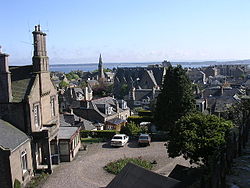
Broughty Ferry is a suburb on the eastern side of the City of Dundee, on the shore of the Firth of Tay in Angus. "The Ferry" was created a burgh in 1864, but absorbed into the Royal Burgh of Dundee in 1913.
Name
The name Broughty Ferry looks like a plain Scots name of Old English roots, but it may derive from the Gaelic Bruach Tatha meaning "Taybank". Local tradition holds that the name derives from the Lowland Scots broch, meaning a fortification, with the 'ty' being a shortening of the name of the River Tay, and Ferry being added later in recognition of the town's role as a ferry port. However, this is unlikely, as the word order would probably be "Tay Broch", rather than "Broch Tay".
History

Evidence exists of a human settlement in pre-historic times, later developing into a prosperous fishing and whaling village, before becoming home to 19th century jute barons who had their factories in Dundee. At this time it was known as the 'richest square mile in Europe'.
In 1495 Broughty Castle was built and remained in use as a major defensive structure until 1932, playing a role in the mediaeval wars that rent the island and in the Wars of the Three Kingdoms. The castle stands on a shallow tip projecting into the Firth, alongside two beaches, one of sand, the other of pebbles.
The village has two Category A listed buildings, St Stephen’s Church (the parish church of the West Ferry) and St Luke’s Church built in the 19th century. St Stephen’s has exceptionally fine Victorian windows thought to be the best collection of Edward Burne-Jones stained glass in the north.
Prior to the construction of the first Tay Rail Bridge in 1878, a roll-on/roll-off railway ferry linked the Edinburgh to Aberdeen railway line between Tayport and Broughty Ferry, until the construction of the rail bridge made it redundant.
On 8 December 1959 the town's lifeboat, the Lifeboat Mona, was lost with all hands attempting to rescue a foundering lightship.
Facilities
Broughty Ferry has a renovated park at the beachfront which includes a number of facilities, such as crazy golf and children's go-karts. On New Year's Day there is a tradition of swimming between the piers of the harbour. A limited train service is available from the railway station.
Culture
Broughty Ferry is the setting for the Bob Servant books and BBC radio and television[1] series written by Neil Forsyth.
Sport
- Bowling:
- Cricket: Forfarshire Cricket Club
- Football: Broughty Athletic FC, who play at Whitton Park
- Rugby: Panmure Rugby FC
- Tennis: Broughty Ferry Tennis Club
The majority of sports activity takes place in Dawson Park which boasts a number of fields and facilities. The park has five football pitches, a rugby union pitch, an American football pitch and several athletics facilities.
In 2006, a new all-weather pitch with floodlights was opened, and is used by the nearby Grove Academy.
Army Cadet Force
Broughty Ferry is home to Grove Blackwatch which is part of the Angus and Dundee Battalion of the Army Cadet Force. It is a youth organisation which is almost 150 years old.
Outside links
[[File:Broughty Ferry - geograph.org.uk - 237056.jpg|right|200px|Broughty Ferry]
- Broughty Ferry
- Broughty Castle (Tourist Information)
- The Broughty Ferry lifeboat
- Visitor's guide to Broughty Ferry
- Broughty Ferry Baptist Church
- Eastern Primary School
- Broughty Athletic Football Club