Hawley, Kent: Difference between revisions
Jump to navigation
Jump to search
Created page with '{{Infobox town |name=Hawley |county=Kent |os grid ref=TQ546715 |latitude=51.4204 |longitude=0.2224 |population= |post town=Dartford |postcode= |dialling code=DA2 |LG district=Dar…' |
mNo edit summary |
||
| Line 2: | Line 2: | ||
|name=Hawley | |name=Hawley | ||
|county=Kent | |county=Kent | ||
|picture=Hawley village, Kent - geograph.org.uk - 242187.jpg | |||
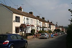
|picture caption=Hawley | |||
|os grid ref=TQ546715 | |os grid ref=TQ546715 | ||
|latitude=51.4204 | |latitude=51.4204 | ||
Latest revision as of 21:22, 23 May 2013
| Hawley | |
| Kent | |
|---|---|
 Hawley | |
| Location | |
| Grid reference: | TQ546715 |
| Location: | 51°25’13"N, -0°13’21"E |
| Data | |
| Post town: | Dartford |
| Dialling code: | DA2 |
| Local Government | |
| Council: | Dartford |
Hawley is a village near Dartford in Kent; a tine place extruded along a lane off the A225 south of Dartford. It is part of the Sutton-at-Hone and Hawley civil parish.
The M25 motorway runs immediately south of the village and the A2 Dartford bypass immediately north, catching it between the two. It has one pub, on the A225, and no church.

This Kent article is a stub: help to improve Wikishire by building it up.