Ronne Ice Shelf: Difference between revisions
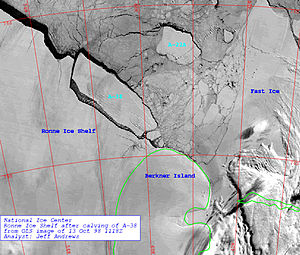
Created page with 'thumb|The calving of the A-38 iceberg off Ronne ice shelf right|thumb|200px|The iceberg splits off the shelf [[Fil…' |
mNo edit summary |
||
| Line 4: | Line 4: | ||
[[File:Rapid Sea Ice Breakup along the Ronne-Filchner Ice Shelf.gif|thumb|Rapid sea ice breakup along the ice shelf]] | [[File:Rapid Sea Ice Breakup along the Ronne-Filchner Ice Shelf.gif|thumb|Rapid sea ice breakup along the ice shelf]] | ||
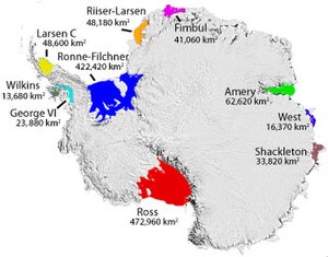
[[File:Moa iceshelves.jpg|thumb|300px|Some named Antarctic iceshelves]] | [[File:Moa iceshelves.jpg|thumb|300px|Some named Antarctic iceshelves]] | ||
The '''Ronne Ice Shelf''' is an ice-shelf covering the southwest part of the [[Weddell Sea]] within the [[British Antarctic Territory]], at {{lat & long|-78.5|-61}}. It adjoins the smaller [[Filchner Ice Shelf]] which lies to the east, the two often known together as the "Ronne-Filchner Ice Shelf" or "Filchner-Ronne Ice Shelf". The two shelves are contiguous but separated by [[Berkner Island]], the largest island of the Weddell Sea]] | The '''Ronne Ice Shelf''' is an ice-shelf covering the southwest part of the [[Weddell Sea]] within the [[British Antarctic Territory]], at {{lat & long|-78.5|-61}}. It adjoins the smaller [[Filchner Ice Shelf]] which lies to the east, the two often known together as the "Ronne-Filchner Ice Shelf" or "Filchner-Ronne Ice Shelf". The two shelves are contiguous but separated by [[Berkner Island]], the largest island of the [[Weddell Sea]] | ||
The two shelves are contiguous but separated by [[Berkner Island]], the largest island of the [[Weddell Sea]], and together they cover some 16,000 square miles, so if taken together they would be the second-largest ice shelf in Antarctica. | The two shelves are contiguous but separated by [[Berkner Island]], the largest island of the [[Weddell Sea]], and together they cover some 16,000 square miles, so if taken together they would be the second-largest ice shelf in Antarctica. | ||
Latest revision as of 13:31, 19 December 2012


The Ronne Ice Shelf is an ice-shelf covering the southwest part of the Weddell Sea within the British Antarctic Territory, at 78°30’0"S, 61°0’0"W. It adjoins the smaller Filchner Ice Shelf which lies to the east, the two often known together as the "Ronne-Filchner Ice Shelf" or "Filchner-Ronne Ice Shelf". The two shelves are contiguous but separated by Berkner Island, the largest island of the Weddell Sea
The two shelves are contiguous but separated by Berkner Island, the largest island of the Weddell Sea, and together they cover some 16,000 square miles, so if taken together they would be the second-largest ice shelf in Antarctica.
South of the twin shelves is Queen Elizabeth Land, part of the Antarctic continent.
Description and name
The shelf is not static: it grows perpetually fed by the slow flow of inland ice sheets. From time to time, when the shearing stresses exceed the strength of the ice, cracks form and large parts of the ice sheet separate from the ice shelf and continue as icebergs; a process known as calving.
The Ronne Ice Shelf is the larger and western part of the Filchner-Ronne shelf. It is bounded on the west by Palmer Land and the unclaimed parts of Antarctica. Commander Finn Ronne of the United States Naval Reserve discovered and photographed a strip along the entire northern portion of this ice shelf in two aircraft flights in November and December 1947, as leader of the Ronne Antarctic Research Expedition of 1947-48,. He named it the "Lassiter Shelf Ice" and gave the name "Edith Ronne Land" to the land presumed to lie south of it, after his wife. In 1957-58 researchers at the American Ellsworth Station, under Captain Ronne (as he now was), determined "Edith Ronne Land" did not exist and that the ice shelf was larger to the south than previously charted, and the Americans' "Advisory Committee on Antarctic Names" approved the name "Ronne Ice Shelf", which name has been accepted by the British authorities.
Deterioration
In October 1998, the iceberg A-38 broke off the Ronne ice shelf; an iceberg larger than Devon. It later broke up into three parts. A similar-sized calving in May 2000 created an iceberg 167 by 20 miles in extent, dubbed A-43 - the disintegration of this is thought to have been responsible for the November 2006 sighting of several large icebergs from the coast of the South Island of New Zealand, the first time that any icebergs had been observed from the New Zealand mainland since 1931. A large group of small icebergs (the largest over half a mile long), were seen off the southeast coast of the island, with one of them drifting close enough to shore to be visible from the hills above the city of Dunedin. If these were indeed the remnants of this calving, then over the course of five and a half years they had travelled slowly north and also east around over half the globe, a journey of some 8,500 miles.[1]
From 12 January and 13 January 2010, an area of sea ice larger than Gloucestershire broke away from the Ronne Ice Shelf and shattered into many smaller pieces.
The ice of the Filchner and Ronne ice shelves can be as thick as 2,000 feet the water below is about 4,600 feet deep at the deepest point.
The international Filchner-Ronne Ice Shelf Programme (FRISP) was initiated in 1973 to study the ice shelf.[2]
References
- ↑ NIWA report, National Institute of Water and Atmospheric Research
- ↑ 6.2.1. Filchner-Ronne Ice Shelf Programme. WAIS: The West Antarctic Ice Sheet Initiative.
Outside links
- "Satellite image/map of Ronne (W)". National Snow and Ice Data Center. 2002-12-03. http://nsidc.org/data/iceshelves_images/ronne_w_loc.html. Retrieved 2008-01-26.
- "Satellite image/map of Filchner (E)". National Snow and Ice Data Center. 2002-12-03. http://nsidc.org/data/iceshelves_images/ronne_e_loc.html. Retrieved 2008-01-26.
- Big Antarctic ice sheet appears doomed; Warming climate predicted to trigger collapse of Filchner-Ronne shelf by 2100 June 2nd, 2012; Vol.181 #11 (p. 5) Science News.