Ham, Kent: Difference between revisions
Jump to navigation
Jump to search
Created page with '{{Infobox town |name=Ham |county=Kent |picture=Hamsandwichroadsign.jpg |picture caption=The famous signpost |os grid ref=TR323546 |latitude=51.244117 |longitude=1.327616 |popula…' |
No edit summary |
||
| Line 22: | Line 22: | ||
{{reflist}} | {{reflist}} | ||
[[File:Piglets in a field on Hay Lane - geograph.org.uk - 691079.jpg|left|200px|Piglets on Hay Lane, Ham]] | |||
{{stub}} | {{stub}} | ||
Revision as of 22:31, 13 November 2012
| Ham | |
| Kent | |
|---|---|
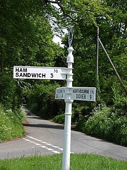
 The famous signpost | |
| Location | |
| Grid reference: | TR323546 |
| Location: | 51°14’39"N, 1°19’39"E |
| Data | |
| Postcode: | CT14 |
| Local Government | |
| Council: | Dover |
Ham is a tiny hamlet in Kent, within the parish of Northbourne, just inland of Deal. The larger village of Eastry is to the west. The town of Sandwich is to the north.
Ham has become well known not for itself but for a nearby fingerpost which points to both the hamlet and the nearby town, thus reading "Ham Sandwich".
| ("Wikimedia Commons" has material about Ham, Kent) |
References


This Kent article is a stub: help to improve Wikishire by building it up.
