Dalton, Stamfordham: Difference between revisions
Jump to navigation
Jump to search
No edit summary |
No edit summary |
||
| Line 15: | Line 15: | ||
|constituency= | |constituency= | ||
}} | }} | ||
'''Dalton''' is a minor hamlet in [[Northumberland]], on the River Pont | '''Dalton''' is a minor hamlet in [[Northumberland]], a mile and a half east of [[Stamfordham]]. It on the [[River Pont]]: [[Ponteland]] is three downstream, to the east. | ||
The hamlet has a little church, Holy Trinity, which was originally built in 1836 as a chapel of ease for the Parish of Newburn by the Collingwood family of [[Dissington Hall]]. It is a Grade II listed building.<ref>{{NHLE|1042698|Church of the Holy Trinity|grade=II}}</ref> | |||
[[File:Dalton Parish Church - geograph.org.uk - 1444996.jpg|left|thumb|200px|Holy Trinity, Dalton]] | |||
{{commons}} | {{commons}} | ||
Revision as of 09:34, 24 December 2023
| Dalton | |
| Northumberland | |
|---|---|

| |
| Location | |
| Grid reference: | NZ110719 |
| Location: | 55°2’32"N, 1°49’41"W |
| Data | |
| Postcode: | NE18 |
| Local Government | |
| Council: | Northumberland |
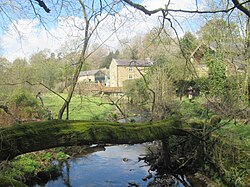
Dalton is a minor hamlet in Northumberland, a mile and a half east of Stamfordham. It on the River Pont: Ponteland is three downstream, to the east.
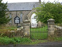
The hamlet has a little church, Holy Trinity, which was originally built in 1836 as a chapel of ease for the Parish of Newburn by the Collingwood family of Dissington Hall. It is a Grade II listed building.[1]

| ("Wikimedia Commons" has material about Dalton, Stamfordham) |
- ↑ National Heritage List 1042698: Church of the Holy Trinity (Grade II listing)
