Nantes River: Difference between revisions
Jump to navigation
Jump to search
Created page with "{{territory|Montserrat}} '''Nantes River''' flows westward through Montserrat, reaching the island's west coast in Lime Kiln Bay. It was known as the Norris River until at..." |
No edit summary |
||
| Line 1: | Line 1: | ||
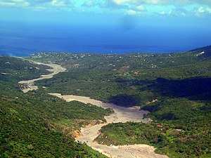
[[File:Montserrat, Karibik - 2012-03-04 - Old Town – Olvestom - Salem - panoramio.jpg|right|300px|The Nantes River valley]] | |||
{{territory|Montserrat}} | {{territory|Montserrat}} | ||
'''Nantes River''' flows westward through [[Montserrat]], reaching the island's west coast in Lime Kiln Bay. It was known as the Norris River until at least 1930. | '''Nantes River''' flows westward through [[Montserrat]], reaching the island's west coast in Lime Kiln Bay. It was known as the Norris River until at least 1930. | ||
Latest revision as of 23:04, 15 December 2022

Nantes River flows westward through Montserrat, reaching the island's west coast in Lime Kiln Bay. It was known as the Norris River until at least 1930.
The river rises in the hills by Hope, close to the Montserrat Volcano Observatory. It then flows westwards, between a busily inhabited area by the island's standards, between Olveston and Old Town, to the sea.
Location
- Location map: 16°45’8"N, 62°13’23"W