Eaton Socon: Difference between revisions
Created page with '{{Infobox town |name=Eaton Socon |county=Bedfordshire |picture=Parish church, Eaton Socon, Hunts - Cambs - geograph.org.uk - 319928.jpg |picture caption=Parish church, Eaton Soco…' |
mNo edit summary |
||
| Line 17: | Line 17: | ||
'''Eaton Socon''' is a village in [[Bedfordshire]] which, though distinct and separated by the river and its meadows, is effectively part of the environs of [[St Neots]] in neighbouring [[Huntingdonshire]]. It stands on the western bank of the River [[Great Ouse]], which here forms the border between the two counties. A neighbouring village along the river is [[Eaton Ford]]. | '''Eaton Socon''' is a village in [[Bedfordshire]] which, though distinct and separated by the river and its meadows, is effectively part of the environs of [[St Neots]] in neighbouring [[Huntingdonshire]]. It stands on the western bank of the River [[Great Ouse]], which here forms the border between the two counties. A neighbouring village along the river is [[Eaton Ford]]. | ||
Because of | Because of its location on the Great Ouse, Eaton Socon was once well served by watermills. Also it was a popular staging area for stage coaches coming up and down the Great North Road, which passes through the village. (The A1 has taken the route over and is bypassed around the village but several of the inns remain.) . | ||
The village is listed as "Etone" in the ''[[Domesday Book]]'', and records that the manor belonged to Eudo Dapfier. In the 13th century the village became a "soken", which meant it was a jurisdiction independent of the local Hundred Court at Barford, hence "Eaton Socon". The village was also previously known as "Sudbury". | The village is listed as "Etone" in the ''[[Domesday Book]]'', and records that the manor belonged to Eudo Dapfier. In the 13th century the village became a "soken", which meant it was a jurisdiction independent of the local Hundred Court at Barford, hence "Eaton Socon". The village was also previously known as "Sudbury". | ||
Latest revision as of 23:06, 11 October 2014
| Eaton Socon | |
| Bedfordshire | |
|---|---|
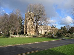
 Parish church, Eaton Socon | |
| Location | |
| Grid reference: | TL165595 |
| Location: | 52°13’12"N, 0°17’24"W |
| Data | |
| Population: | 5,547 (2001) |
| Post town: | St Neots |
| Postcode: | PE19 |
| Dialling code: | 01480 |
| Local Government | |
| Council: | Huntingdonshire |
| Parliamentary constituency: |
Huntingdon |
Eaton Socon is a village in Bedfordshire which, though distinct and separated by the river and its meadows, is effectively part of the environs of St Neots in neighbouring Huntingdonshire. It stands on the western bank of the River Great Ouse, which here forms the border between the two counties. A neighbouring village along the river is Eaton Ford.
Because of its location on the Great Ouse, Eaton Socon was once well served by watermills. Also it was a popular staging area for stage coaches coming up and down the Great North Road, which passes through the village. (The A1 has taken the route over and is bypassed around the village but several of the inns remain.) .
The village is listed as "Etone" in the Domesday Book, and records that the manor belonged to Eudo Dapfier. In the 13th century the village became a "soken", which meant it was a jurisdiction independent of the local Hundred Court at Barford, hence "Eaton Socon". The village was also previously known as "Sudbury".
Modernising an old village
Eaton Socon changed relatively little until this time, but when the planners decided to force it into the St Neots urban area a significant amount of development took place to the west of the village into the 1980s, with areas covering Monarch Road and the upper end of Nelson Road being developed in a particularly short space of time. The population of Eaton Socon is around 5,000 people.
The village

The centre of Eaton Socon is characterised by small thatched cottages along the Great North Road and side roads such as Peppercorns Lane and School Lane. Great North Road is lined with a number of local business premises. The White Horse pub dates back to the 13th Century, was a Royal Mail staging post and is mentioned by Charles Dickens in Nicholas Nickleby. The village retains a great deal of atmosphere and traditional May Day celebrations are still held every year on the green.
Eaton Socon lies close to the west bank of the River Great Ouse. There is a weir (built in 1967) and associated lock gates to allow river navigation. The riverbank is home to a popular local inn, The River Mill Tavern. Nearby on Castle Hill are the remains of Eaton Socon Castle, long since fallen.
The parish church, St Mary's, stands on the picturesque green in the centre of the village. It burned down in the 1930s after a fire started in the organ, but was completely rebuilt in the original style soon after.
Today most visitors come to see the remains of Bushmead Priory. The Priory was established in 1195 as an Augustinian house, and retains mediæval stained glass and wall paintings.
The A1 passed through the village along the Great North Road until the Eaton Socon bypass opened in 1971. A second, southern, bypass was opened in 1985 to enable traffic travelling between the A1 and Cambridge to avoid Eaton Socon, Eaton Ford and St Neots.
Outside links
| ("Wikimedia Commons" has material about Eaton Socon) |
- Eatons Community Association
- Eaton Socon on the Great North Road
- www.stneots-tc.gov.uk – Contains information on Eaton Socon
- Genealogy of Eaton Socon (and Hamlets)
