Kemp Island: Difference between revisions
Jump to navigation
Jump to search
Created page with "{{Infobox island |name=Kemp Island |territory=SGSSI |picture= |picture caption= |latitude=-55.035 |longitude=-34.7344 |group=Clerke Rocks |map=Kemp Island - Clerke Rocks.svg |..." |
No edit summary |
||
| Line 8: | Line 8: | ||
|group=Clerke Rocks | |group=Clerke Rocks | ||
|map=Kemp Island - Clerke Rocks.svg | |map=Kemp Island - Clerke Rocks.svg | ||
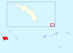
|map caption=Location of Kemp Island | |||
|summit=800 feet | |summit=800 feet | ||
}} | }} | ||
Latest revision as of 14:28, 8 November 2021
| Kemp Island | |
| Location | |
| Location: | 55°2’6"S, 34°44’4"W |
| Highest point: | 800 feet |
| Data | |
Kemp Island is the largest of the westerly group of the Clerke Rocks. It is a small island, roughly circular with a maximum length of a thousand yards and a double summit, the highest peak being some 800 feet above mean sea level.
The island supports large breeding colonies of Antarctic seabirds.
Kemp Island is named after Arthur Kemp(e), First Lieutenant on HMS Adventure, which accompanied Cook on his second voyage of exploration when he discovered Clerke Rocks in 1775.
References
- Gazetteer and Map of South Georgia and the South Sandwich Islands: Kemp Island
