Charfield: Difference between revisions
Created page with "{{Infobox town |name=Charfield |county=Gloucestershire |picture=St. James church, Churchend - geograph.org.uk - 195886.jpg |picture caption=St. James church, Churchend |os gri..." |
No edit summary |
||
| Line 17: | Line 17: | ||
'''Charfield''' is a village in [[Gloucestershire]], sitting to the south-west of [[Wotton-under-Edge]] near the [[Little Avon River]] and the villages of [[Falfield]] and [[Cromhall]], in the south of the county. | '''Charfield''' is a village in [[Gloucestershire]], sitting to the south-west of [[Wotton-under-Edge]] near the [[Little Avon River]] and the villages of [[Falfield]] and [[Cromhall]], in the south of the county. | ||
Just to the south is a hamlet, [[Churchend, Gloucestershire|Churchend]], | Just to the south is a hamlet, [[Churchend, Gloucestershire|Churchend]], which used to be the church hamlet, though its church, St James, is now closed. | ||
==Churches== | ==Churches== | ||
Revision as of 13:53, 20 November 2019
| Charfield | |
| Gloucestershire | |
|---|---|
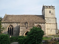
 St. James church, Churchend | |
| Location | |
| Grid reference: | ST722920 |
| Location: | 51°37’37"N, 2°24’9"W |
| Data | |
| Population: | 2,538 (2011) |
| Post town: | Wotton-Under-Edge |
| Postcode: | GL12 |
| Local Government | |
| Council: | South Gloucestershire |
| Parliamentary constituency: |
Thornbury and Yate |
Charfield is a village in Gloucestershire, sitting to the south-west of Wotton-under-Edge near the Little Avon River and the villages of Falfield and Cromhall, in the south of the county.
Just to the south is a hamlet, Churchend, which used to be the church hamlet, though its church, St James, is now closed.
Churches
Within Charfield stands the parish church, St John.
The old parish church is at Churchend, on a steep hillside overlooking a valley, is St James' Church, which today is under the care of the Churches Conservation Trust.[1] It is a Grade I listed building.[2]
The church originates from the 13th century. It was largely rebuilt in the 15th century, using money from the local wool trade. During the 18th century the industry moved into the valley, isolating the church. It was repaired during the 1970s.
Village
This is a medium-sized village of about 2,500 residents with three pubs, the Pear Tree, Railway Tavern and The Plough Inn, a convenience store with Post Office and the church.
There are six main housing areas. Farm Lees, Longs View, Manor Lane and Woodlands have existed for some time. Two new housing developments were built in 2018-2019: St James Mews, opposite St James Church, and Charfield Village, at the eastern end of the village near the Renishaw PLC site. The primary school has around 250 students.
Railway
The Bristol to Birmingham main railway line runs through the village. Charfield railway station closed in January 1965 but still stands, and discussions continue about the viability of re-opening it.
On 13 October 1928 the village was the scene of a fatal train crash, known as the Charfield railway disaster. The Leeds to Bristol London, Midland and Scottish Railway night mail train crashed under a road bridge near Charfield Station, killing 15 and injuring 23. Amongst the dead were two children whose remains could not be identified.
Sport and leisure
Charfield Memorial Hall and Playing Field is in the centre of Charfield. The Hall has recently been refurbished and the play area upgraded with new equipment.[3]
Outside links
| ("Wikimedia Commons" has material about Charfield) |
References
- ↑ St James' Church, Charfield, Gloucestershire: Churches Conservation Trust]
- ↑ National Heritage List 1321189: Church of St James, Charfield
- ↑ Charfield Community
