Sgùrr Breac: Difference between revisions
Jump to navigation
Jump to search
Created page with '{{Infobox hill |name=Sgùrr Breac |county=Cromartyshire |range=Fannichs |height=3,278 feet |picture=Sgùrr Breac from Sgùrr nan Clach Geala - geograph.org.uk - 917805.jpg |pictu…' |
mNo edit summary |
||
| Line 12: | Line 12: | ||
The mountain is in the western part Fannichs. It has very steep face to the north. It is well seperated from Sgurr nan Clach Geala and is not normally ascended as part of the same walk, but may be climbed conveniently with its neighbour, [[A' Chaillleach]]. The usual approach is from the A832 to the north, and up the ridge which rises from the foot of [[Loch A' Bhraoin]]. | The mountain is in the western part Fannichs. It has very steep face to the north. It is well seperated from Sgurr nan Clach Geala and is not normally ascended as part of the same walk, but may be climbed conveniently with its neighbour, [[A' Chaillleach]]. The usual approach is from the A832 to the north, and up the ridge which rises from the foot of [[Loch A' Bhraoin]]. | ||
{{Munro}} | |||
Revision as of 12:17, 19 October 2013
| Sgùrr Breac | |||
| Cromartyshire | |||
|---|---|---|---|
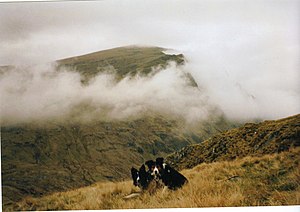
 Sgùrr Breac from Sgùrr nan Clach Geala | |||
| Range: | Fannichs | ||
| Summit: | 3,278 feet NH158711 | ||
Sgùrr Breac is a mountain in the range known as the Fannichs, one of the nine "munros" in that range, which is to say mountains above 3,000 feet. Sgùrr Breac itself stands at 3,278 feet at its summit. It is in the Forest of Fannich, belonging to Cromartyshire.
The mountain is in the western part Fannichs. It has very steep face to the north. It is well seperated from Sgurr nan Clach Geala and is not normally ascended as part of the same walk, but may be climbed conveniently with its neighbour, A' Chaillleach. The usual approach is from the A832 to the north, and up the ridge which rises from the foot of Loch A' Bhraoin.