Belsford: Difference between revisions
Jump to navigation
Jump to search
Created page with "{{Infobox town |name=Belsford |county=Devon |picture=Track to Langford Barn - geograph.org.uk - 1160638.jpg |picture caption=Track from Belsford |os grid ref=SX7659 |latitude=..." |
No edit summary |
||
| Line 4: | Line 4: | ||
|picture=Track to Langford Barn - geograph.org.uk - 1160638.jpg | |picture=Track to Langford Barn - geograph.org.uk - 1160638.jpg | ||
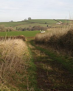
|picture caption=Track from Belsford | |picture caption=Track from Belsford | ||
|os grid ref= | |os grid ref=SX766593 | ||
|latitude=50.421205 | |latitude=50.421205 | ||
|longitude=-3.738391 | |longitude=-3.738391 | ||
|population= | |population= | ||
|post town= | |post town=Totnes | ||
|postcode= | |postcode=TQ9 | ||
|dialling code= | |dialling code= | ||
|LG district= | |LG district= | ||
|constituency= | |constituency= | ||
}} | }} | ||
'''Belsford''' is a village in the south of [[Devon]], on the rolling green slopes at the edge of [[Dartmoor]] at the end of a dead-end lane from [[Harberton]], and two miles south-west of [[Totnes]. | '''Belsford''' is a village in the south of [[Devon]], on the rolling green slopes at the edge of [[Dartmoor]] at the end of a dead-end lane from [[Harberton]], and two miles south-west of [[Totnes]]. | ||
==Outside links== | ==Outside links== | ||
{{Commons}} | {{Commons}} | ||
Latest revision as of 21:44, 28 March 2018
| Belsford | |
| Devon | |
|---|---|
 Track from Belsford | |
| Location | |
| Grid reference: | SX766593 |
| Location: | 50°25’16"N, 3°44’18"W |
| Data | |
| Post town: | Totnes |
| Postcode: | TQ9 |
| Local Government | |
Belsford is a village in the south of Devon, on the rolling green slopes at the edge of Dartmoor at the end of a dead-end lane from Harberton, and two miles south-west of Totnes.
Outside links
| ("Wikimedia Commons" has material about Belsford) |
