Watership Down: Difference between revisions
Created page with "{{Infobox hill |name=Watership Down |county=Hampshire |range=Hampshire Downs |picture=Watership from northeast.jpg |picture caption=Watership Down, from the northeast |os grid..." |
No edit summary |
||
| Line 2: | Line 2: | ||
|name=Watership Down | |name=Watership Down | ||
|county=Hampshire | |county=Hampshire | ||
|range=Hampshire Downs | |range=North Hampshire Downs | ||
|picture=Watership from northeast.jpg | |picture=Watership from northeast.jpg | ||
|picture caption=Watership Down, from the northeast | |picture caption=Watership Down, from the northeast | ||
| Line 10: | Line 10: | ||
|height=778 feet | |height=778 feet | ||
}} | }} | ||
'''Watership Down''' is a hill amongst the rolling [[Hampshire Downs]], standing above [[Ecchinswell]] in [[Hampshire]]. In common with the other chalk hills along the ridge of the downs, it displays a very steep escarpment on its northern flank, descending in a gentle dip slope to the south. At its highest, the hill reaches 778 feet above sea level. | '''Watership Down''' is a hill amongst the rolling [[North Hampshire Downs]], standing above [[Ecchinswell]] in [[Hampshire]]. In common with the other chalk hills along the ridge of the downs, it displays a very steep escarpment on its northern flank, descending in a gentle dip slope to the south. At its highest, the hill reaches 778 feet above sea level. | ||
The closest village beneath its scarp is [[Sydmonton]], with its great house, Symonton Court, while to the north is Ecchinswell, and the larger village of [[Kingsclere]] to the west of it. | The closest village beneath its scarp is [[Sydmonton]], with its great house, Symonton Court, while to the north is Ecchinswell, and the larger village of [[Kingsclere]] to the west of it. | ||
Latest revision as of 22:53, 28 November 2017
| Watership Down | |||
| Hampshire | |||
|---|---|---|---|
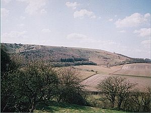
 Watership Down, from the northeast | |||
| Range: | North Hampshire Downs | ||
| Summit: | 778 feet SU497570 51°18’36"N, 1°17’18"W | ||
Watership Down is a hill amongst the rolling North Hampshire Downs, standing above Ecchinswell in Hampshire. In common with the other chalk hills along the ridge of the downs, it displays a very steep escarpment on its northern flank, descending in a gentle dip slope to the south. At its highest, the hill reaches 778 feet above sea level.
The closest village beneath its scarp is Sydmonton, with its great house, Symonton Court, while to the north is Ecchinswell, and the larger village of Kingsclere to the west of it.
The Down is best known as the setting for the 1972 novel; Watership Down by Richard Adams;.[1] a novel about rabbits.
The area is popular with cyclists and walkers. A bridleway, the Wayfarer's Walk cross county footpath, runs along the ridge of the Down, from Walbury Hill (Hampshire's and Berkshire's county top), over Pilot Hill and on to Watership Down, where it leaves the ridge to head southwards.
The hill has a partially completed Iron Age hill fort on its summit, and the surrounding area is rich in Iron Age tumuli, enclosures, lynchets and field systems. Further to the west lies Beacon Hill.
Conservation
The hill lies at the south-eastern edge of the North Wessex Downs Area of Natural Beauty. Other nearby features include Ladle Hill, on Great Litchfield Down, immediately to the west.
Part of the hill is a 26-acre biological 'Site of Special Scientific Interest', first notified in 1978.
Outside links
| ("Wikimedia Commons" has material about Watership Down) |
References
- ↑ Watership Down (Worldcat)
