Loch Calder: Difference between revisions
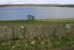
Created page with "{{county|Caithness}} thumb|250px|Loch Calder looking west '''Loch Calder''' is a lowland freshwater loch in Caithness l..." |
|||
| Line 15: | Line 15: | ||
*Location map: {{wmap|58.516667|-3.583333|zoom=14}} | *Location map: {{wmap|58.516667|-3.583333|zoom=14}} | ||
[[Category:Lochs of Caithness]] | [[Category:Lochs of Caithness|Calder]] | ||
Latest revision as of 19:55, 23 May 2022

Loch Calder is a lowland freshwater loch in Caithness lying approximately five miles south-west of Thurso. The loch is large with an irregular shape and has perimeter of eight miles. It is approximately 2½ miles long, has an average depth of 21 ft and is 85 ft at its deepest. The loch was surveyed[1] on 6 October 1902 by John Parsons and T.R.H. Garrett and later charted[2] as part of Sir John Murray's Bathymetrical Survey of Fresh-Water Lochs of Scotland 1897-1909.
Around the loch are several archaeological remains. At the northern end of the loch is Tulach an t'Sionnaich, a well preserved chambered cairn, one of two cairns known as the Tullochs of Assery.[3] On the eastern shore, near Achavarn, lies the site of a broch, although much of the structure has been removed.[4] It is thought that there was an artificial island or crannog near the western shore dating from the 17th century. The island, known as Big Island, may have contained a dwelling which was said to be that of a robber.[5] A short distance to the west of the loch is Aultan Broubster a ruined stone circle. Several of the stones remain, five of which are upright with the largest being 4ft 3in high.[6]
The loch is a Site of Special Scientific Interest for its Greenland white-fronted goose, Greylag goose and Whooper swans.[7]
The loch is popular for fishing and contains trout, Arctic char and ferox trout.[8]
References
- ↑ "Bathymetrical Survey of the Fresh-Water Lochs of Scotland, 1897-1909, Lochs of the Forss Basin". http://maps.nls.uk/bathymetric/text.cfm?seq=1299. Retrieved 12 June 2016.
- ↑ "Loch Calder; Loch Shurrery (Vol. 5, Plate 7), Bathymetrical Survey, 1897-1909". http://maps.nls.uk/view/74422297. Retrieved 12 June 2016.
- ↑ "Tulloch Of Assery". Historic Environment Scotland. https://canmore.org.uk/site/7907/tulloch-of-assery. Retrieved 2016-06-12.
- ↑ "Tulloch Of Achavarn". Historic Environment Scotland. https://canmore.org.uk/site/7645/tulloch-of-achavarn. Retrieved 2016-06-12.
- ↑ "Big Island, Loch Calder". Historic Environment Scotland. https://canmore.org.uk/site/7906/big-island-loch-calder. Retrieved 2016-06-12.
- ↑ "Aultan Broubster". Historic Environment Scotland. https://canmore.org.uk/site/7705/aultan-broubster. Retrieved 2016-06-12.
- ↑ "Loch Calder". http://gateway.snh.gov.uk/sitelink/siteinfo.jsp?pa_code=1711. Retrieved 2016-06-12.
- ↑ "Caithness Lochs wild brown trout fishing". http://www.troutquest.com/caithness-g.asp. Retrieved 2016-06-12.
Outside links
- Location map: 58°31’0"N, 3°34’60"W