Bonchester Bridge: Difference between revisions
Jump to navigation
Jump to search
Created page with "{{Infobox town |name=Bonchester Bridge |county=Roxburghshire |picture=Bonchester Bridge - geograph.org.uk - 3089228.jpg |picture caption=Bonchester Bridge |os grid ref=NT58611..." |
No edit summary |
||
| Line 13: | Line 13: | ||
|constituency=Berwickshire, Roxburgh and Selkirk | |constituency=Berwickshire, Roxburgh and Selkirk | ||
}} | }} | ||
'''Bonchester Bridge''' is a hamlet in [[ | '''Bonchester Bridge''' is a hamlet in the parish of [[Hobkirk]], within [[Roxburghshire]], sitting beside the [[Rule Water]], six miles away from the busy market town of [[Hawick]]. | ||
[[Bonchester Hill]] to the east of the village rises to 1,059 feet and is topped by a hill fort. | [[Bonchester Hill]] to the east of the village rises to 1,059 feet and is topped by a hill fort. | ||
Latest revision as of 18:48, 4 December 2016
| Bonchester Bridge | |
| Roxburghshire | |
|---|---|
 Bonchester Bridge | |
| Location | |
| Grid reference: | NT586119 |
| Location: | 55°23’60"N, 2°39’19"W |
| Data | |
| Post town: | Hawick |
| Postcode: | TD9 |
| Dialling code: | 01450 |
| Local Government | |
| Council: | Scottish Borders |
| Parliamentary constituency: |
Berwickshire, Roxburgh and Selkirk |
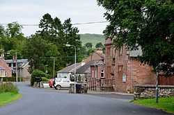
Bonchester Bridge is a hamlet in the parish of Hobkirk, within Roxburghshire, sitting beside the Rule Water, six miles away from the busy market town of Hawick.
Bonchester Hill to the east of the village rises to 1,059 feet and is topped by a hill fort.
In 2010 the Bonchester Bridge community formed Bonchester Brass, the village brass band, to serve its annual civic, church and historical events. The village had a primary school. Hobkirk Primary School, which however shut down in 2015.
Outside links
| ("Wikimedia Commons" has material about Bonchester Bridge) |
