Linton, Northumberland: Difference between revisions
Jump to navigation
Jump to search
Created page with "{{Infobox town |name=Linton |county=Northumberland |picture=North Linton Farm - geograph.org.uk - 298899.jpg |picture caption=North Linton Farm |os grid ref=NZ262912 |latitud..." |
No edit summary |
||
| Line 15: | Line 15: | ||
|website= | |website= | ||
}} | }} | ||
Linton is a tiny village south of the [[River Lyne]] in [[Northumberland]]. It is found along a lane west of the A1068, the trunk road for the coastal villages, west of [[Ellington]]. | '''Linton''' is a tiny village south of the [[River Lyne]] in [[Northumberland]]. It is found along a lane west of the A1068, the trunk road for the coastal villages, west of [[Ellington]]. | ||
The wider parish of Linton includes North Linton Farm, north of the Lyne, and South Linton, north of the current village but south of the Lyne. | The wider parish of Linton includes North Linton Farm, north of the Lyne, and South Linton, north of the current village but south of the Lyne. | ||
Latest revision as of 22:17, 18 March 2016
| Linton | |
| Northumberland | |
|---|---|
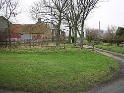
 North Linton Farm | |
| Location | |
| Grid reference: | NZ262912 |
| Location: | 55°12’54"N, 1°35’19"W |
| Data | |
| Local Government | |
| Council: | Northumberland |
Linton is a tiny village south of the River Lyne in Northumberland. It is found along a lane west of the A1068, the trunk road for the coastal villages, west of Ellington.
The wider parish of Linton includes North Linton Farm, north of the Lyne, and South Linton, north of the current village but south of the Lyne.

The village seen today is an entirely new, rectilinear Bellway Homes development south of South Linton Farm, on the site of the old Linton Colliery, by which name the new village is frequently known.