Petrel Island: Difference between revisions
Jump to navigation
Jump to search
Created page with "{{county|South Georgia and the South Sandwich Islands}} '''Petrel Island''' is an island lying three-quarters of a mile southwest of Prion Island, in the Bay of Isles,..." |
No edit summary |
||
| Line 1: | Line 1: | ||
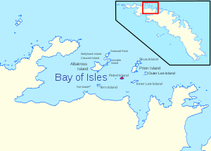
{{ | [[File:Petrel Island - Bay of Isles, South Georgia.svg|right|thumb|300px|Location of Petrel Island]] | ||
{{territory|South Georgia and the South Sandwich Islands}} | |||
'''Petrel Island''' is an island lying three-quarters of a mile southwest of [[Prion Island]], in the [[Bay of Isles]], [[South Georgia]]. | '''Petrel Island''' is an island lying three-quarters of a mile southwest of [[Prion Island]], in the [[Bay of Isles]], [[South Georgia]]. | ||
Latest revision as of 20:20, 12 June 2020

Petrel Island is an island lying three-quarters of a mile southwest of Prion Island, in the Bay of Isles, South Georgia.
The islands was first charted in 1912-13 by Robert Cushman Murphy, American naturalist aboard the brig Daisy. It was recharted in 1929-30 by Discovery Investigation personnel, who so named it because of its association with Prion Island (Prions have been observed in these islands). All but two of the islands in the Bay of isles are named after birds.
References
- Gazetteer and Map of South Georgia and the South Sandwich Islands: Petrel Island
- Location: -54.033 -37.283