Forest, Guernsey: Difference between revisions
Created page with "{{Infobox island parish |name=The Forest |guernesiais=La Fouarêt |bailiwick=Guernsey |picture=Ste Marguerite de la Foret (Forest Church).jpg |picture caption=Ste Marguerite d..." |
No edit summary |
||
| Line 8: | Line 8: | ||
|latitude=49.4258 | |latitude=49.4258 | ||
|longitude=-2.5976 | |longitude=-2.5976 | ||
|area= | |area=138 acres | ||
|population=1,549 | |population=1,549 | ||
}} | }} | ||
| Line 18: | Line 18: | ||
==Geography== | ==Geography== | ||
The Forest is in the south of [[Guernsey]]. It borders [[ | The Forest is in the south of [[Guernsey]]. It borders [[Saint Peter's, Guernsey|St Peter's]] in the west, [[Saint Saviour, Guernsey|St Saviour's]] in the north-west, [[Saint Andrew, Guernsey|St Andrew's]] in the north and [[Saint Martin, Guernsey|St Martin's]] in the east. | ||
The land is generally high up, reaching the island's (though not the Bailiwick's) highest point at around 350 feet. The only low areas are at the coast, where there are steep cliffs. | The land is generally high up, reaching the island's (though not the Bailiwick's) highest point at around 350 feet. The only low areas are at the coast, where there are steep cliffs. | ||
Revision as of 20:34, 25 September 2015
| The Forest | |
| Guernsey | |
|---|---|
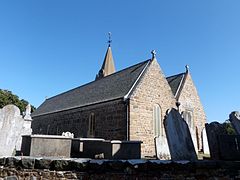
 Ste Marguerite de la Foret parish church | |
 | |
| Area: | 138 acres |
| Population: | 1,549 |
| Location: | 49°25’33"N, 2°35’51"W |
The Forest is a parish of Guernsey: its full name is 'Ste Marguerite de la Foret', the dedication of the parish church. The Forest is the highest parish on the island, with altitudes of up to about 350 feet.
Guernsey Airport is in this parish.
The old Guernésiais nickname for people who were from La Fouarêt was bourdaons.
Geography
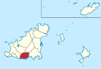
The Forest is in the south of Guernsey. It borders St Peter's in the west, St Saviour's in the north-west, St Andrew's in the north and St Martin's in the east.
The land is generally high up, reaching the island's (though not the Bailiwick's) highest point at around 350 feet. The only low areas are at the coast, where there are steep cliffs.
The south coast's cliffs are interrupted by some beaches. The beaches in The Forest include:
- Le Portelet (inaccessible from land; it can be accessed by swimming from Petit Bôt or by boat)
- Part of Petit Bôt
A pleasant cliff walk along the south coast is available though the parish.
Main roads

The following main roads (listed from West-East) provide important links between The Forest and the other parishes:
- Rue De Manoir (leads to Torteval)
- Rue De Farras (leads to St Peter's)
- Route Des Blicqs (leads to St Andrew's, St Peter Port and the North of the island)
- Forest Road (leads to St Martin's)
The following main roads (listed from West-East) are also very important as they provide access to the Parish Centre and the Airport:
- Rue Des Landes
- Le Bourg
References
| Parishes of the Bailiwick of Guernsey |
|---|
|
Guernsey: St Andrew's • Castel • Forest • St Martin's • St Peter's • St Peter Port • St Sampson • St Saviour's • Torteval • Vale |