Loch Monar: Difference between revisions
Jump to navigation
Jump to search
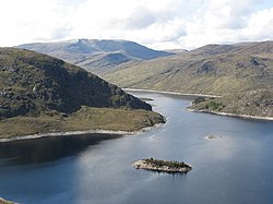
Created page with "{{county|Ross}} thumb|250px|Southern end of Loch Monar '''Loch Monar''' is a freshwater loch situated a..." |
No edit summary |
||
| Line 7: | Line 7: | ||
Much of the area around Loch Monar is remote and mountainous. This include the Munros of [[Sgùrr a' Chaorachain]], [[Sgùrr Choinnich]], [[Maoile Lunndaidh]], [[Lurg Mhòr]] and [[Bidein a' Choire Sheasgaich]]. | Much of the area around Loch Monar is remote and mountainous. This include the Munros of [[Sgùrr a' Chaorachain]], [[Sgùrr Choinnich]], [[Maoile Lunndaidh]], [[Lurg Mhòr]] and [[Bidein a' Choire Sheasgaich]]. | ||
Location map: {{wmap|57.42|-5.1 | ==Outside links== | ||
{{commons}} | |||
*Location map: {{wmap|57.42|-5.1|zoom=13}} | |||
{{DEFAULTSORT:Monar}} | {{DEFAULTSORT:Monar}} | ||
[[Category:Lochs of Inverness-shire]] | [[Category:Lochs of Inverness-shire]] | ||
[[Category:Lochs of Ross-shire]] | [[Category:Lochs of Ross-shire]] | ||
Latest revision as of 17:58, 15 November 2018

Loch Monar is a freshwater loch situated at the head of Glen Strathfarrar, in the counties of Inverness and Ross. The centre of the loch marks the border between the two as far as the Allt Mholain. Since the 1960s, the loch has been dammed as part of the Affric-Beauly hydro-electric power scheme.
It is fed by a number of small burns running off the surrounding hills. The loch's primary outflow is the Garbh-uisge, which joins with the Uisge Misgeach to form the River Farrar.
Much of the area around Loch Monar is remote and mountainous. This include the Munros of Sgùrr a' Chaorachain, Sgùrr Choinnich, Maoile Lunndaidh, Lurg Mhòr and Bidein a' Choire Sheasgaich.
Outside links
| ("Wikimedia Commons" has material about Loch Monar) |
- Location map: 57°25’12"N, 5°6’-0"W
