Letterston: Difference between revisions
Jump to navigation
Jump to search
Created page with "{{county|Pembrokeshire}} '''Letterston''' is a rapidly growing village and parish located in the north of Pembrokeshire between Haverfordwest 10 miles to the south and..." |
No edit summary |
||
| Line 1: | Line 1: | ||
{{county|Pembrokeshire}} | {{county|Pembrokeshire}} | ||
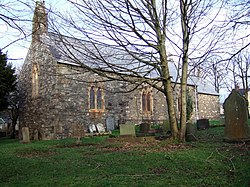
'''Letterston''' is a rapidly growing village and parish located in the north of [[Pembrokeshire]] between [[Haverfordwest]] 10 miles to the south and [[Fishguard]] 6½ miles north on the A40 road. The village's name is derived from the Flemish settler known as Letard Litelking.<ref>[http://www.roll-of-honour.com/Pembrokeshire/Letterston.html Roll-of-honour.com]</ref> | [[File:St Giles, Treletert-Letterston - geograph.org.uk - 958703.jpg|thumb|250px|St Giles parish church]] | ||
'''Letterston''' is a rapidly growing village and parish located in the north of [[Pembrokeshire]] between [[Haverfordwest]], 10 miles to the south and [[Fishguard]], 6½ miles north on the A40 road. The village's name is derived from the Flemish settler known as Letard Litelking.<ref>[http://www.roll-of-honour.com/Pembrokeshire/Letterston.html Roll-of-honour.com]</ref> The parish church is dedicated to St Giles. | |||
{{ | In 2011, the population was recorded as 1,245.<ref>{{cite web|url=https://neighbourhood.statistics.gov.uk/dissemination/LeadKeyFigures.do?a=7&b=11125567&c=SA62+5SQ&d=16&e=62&g=6491711&i=1001x1003x1032x1004&m=0&r=0&s=1429456052594&enc=1|title=Community population 2011|accessdate=19 April 2015}}</ref> | ||
==References== | ==References== | ||
{{reflist}} | {{reflist}} | ||
==Outside links== | |||
*Location map: {{wmap|51.92694|-4.99583|zoom=14}} | |||
[[Category:Towns and villages in Pembrokeshire]] | [[Category:Towns and villages in Pembrokeshire]] | ||
{{stub}} | {{stub}} | ||
Latest revision as of 11:12, 29 January 2019

Letterston is a rapidly growing village and parish located in the north of Pembrokeshire between Haverfordwest, 10 miles to the south and Fishguard, 6½ miles north on the A40 road. The village's name is derived from the Flemish settler known as Letard Litelking.[1] The parish church is dedicated to St Giles.
In 2011, the population was recorded as 1,245.[2]
References
Outside links
- Location map: 51°55’37"N, 4°59’45"W

This Pembrokeshire article is a stub: help to improve Wikishire by building it up.