River Elan: Difference between revisions
Created page with "thumb|right|Footbridge over the River Elan below Caban Coch dam The '''River Elan'''..." |
No edit summary |
||
| Line 1: | Line 1: | ||
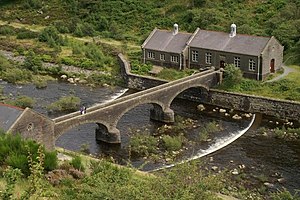
[[File:Footbridge over the Afon Elan below Caban Coch dam - geograph.org.uk - 508431.jpg|thumb|right|Footbridge over the River Elan below Caban Coch dam]] | [[File:Footbridge over the Afon Elan below Caban Coch dam - geograph.org.uk - 508431.jpg|thumb|right|Footbridge over the River Elan below Caban Coch dam]] | ||
The '''River Elan''' is a tributary of the [[River Wye]] which runs through the wide expanse of upland moors, traditionally known as Elenydd, in central [[Wales]]. Its valley is known as the Elan Valley. The name probably arises from ''elain'' meaning 'hind' or 'fawn' in reference perhaps to the rushing, bounding nature of its course.<ref>Owen, W.W. and Morgan, R. 2007 ''Dictionary of the Place-names of Wales'' Gomer Press, | The '''River Elan''' is a tributary of the [[River Wye]] which runs through the wide expanse of upland moors, traditionally known as Elenydd, in central [[Wales]]. Its valley is known as the Elan Valley. The name probably arises from ''elain'' meaning 'hind' or 'fawn' in reference perhaps to the rushing, bounding nature of its course.<ref>Owen, W.W. and Morgan, R. 2007 ''Dictionary of the Place-names of Wales'' Gomer Press, Cardiganshire ISBN 9781843239017</ref> | ||
It has its source in wet moorland on the eastern flank of Pen y Deunant in [[Cardiganshire]], It is joined by Nant Dderwen, Nant Cwta and Nant Hirin before entering the top of the Elan Valley Reservoirs at Craig Goch Reservoir which in turn discharges to Garreg-ddu Reservoir and then Caban-coch Reservoir. It emerges from this chain of reservoirs in a north-easterly direction and forms the county boundary between [[Radnorshire]] and [[Brecknockshire]] for the rest of its journey. It passes through [[Elan Village]] before turning south-east after two miles and making its confluence with the [[River Wye]].<ref>Ordnance Survey 1:25,000 scale Explorer map sheets 200 ''Llandrindod Wells & Elan Valley'' and 214 ''Llanidloes & Newtown''</ref> | It has its source in wet moorland on the eastern flank of Pen y Deunant in [[Cardiganshire]], It is joined by Nant Dderwen, Nant Cwta and Nant Hirin before entering the top of the Elan Valley Reservoirs at Craig Goch Reservoir which in turn discharges to Garreg-ddu Reservoir and then Caban-coch Reservoir. It emerges from this chain of reservoirs in a north-easterly direction and forms the county boundary between [[Radnorshire]] and [[Brecknockshire]] for the rest of its journey. It passes through [[Elan Village]] before turning south-east after two miles and making its confluence with the [[River Wye]].<ref>Ordnance Survey 1:25,000 scale Explorer map sheets 200 ''Llandrindod Wells & Elan Valley'' and 214 ''Llanidloes & Newtown''</ref> | ||
Revision as of 13:35, 28 October 2014

The River Elan is a tributary of the River Wye which runs through the wide expanse of upland moors, traditionally known as Elenydd, in central Wales. Its valley is known as the Elan Valley. The name probably arises from elain meaning 'hind' or 'fawn' in reference perhaps to the rushing, bounding nature of its course.[1]
It has its source in wet moorland on the eastern flank of Pen y Deunant in Cardiganshire, It is joined by Nant Dderwen, Nant Cwta and Nant Hirin before entering the top of the Elan Valley Reservoirs at Craig Goch Reservoir which in turn discharges to Garreg-ddu Reservoir and then Caban-coch Reservoir. It emerges from this chain of reservoirs in a north-easterly direction and forms the county boundary between Radnorshire and Brecknockshire for the rest of its journey. It passes through Elan Village before turning south-east after two miles and making its confluence with the River Wye.[2]
References
Coordinates: 52°17′N 3°31′W / 52.283°N 3.517°W
This article is a stub: help to improve Wikishire by building it up.