Foel-fras: Difference between revisions
No edit summary |
No edit summary |
||
| Line 6: | Line 6: | ||
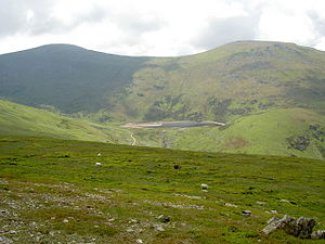
|picture caption=Foel-fras (L) and Llwytmor (R) from the Drum ridge. | |picture caption=Foel-fras (L) and Llwytmor (R) from the Drum ridge. | ||
|os grid ref=SH696681 | |os grid ref=SH696681 | ||
|latitude=53.193948 | |||
|longitude=-3.953330 | |||
|height=3,091 feet | |height=3,091 feet | ||
}} | }} | ||
'''Foel-fras''' is a mountain in the Carneddau range of [[Snowdonia]] in [[Caernarfonshire]], about | '''Foel-fras''' is a mountain in the Carneddau range of [[Snowdonia]] in [[Caernarfonshire]], about seven miles east of [[Bethesda, Caernarfonshire]]. With a height rising to a summit at 3,091 feet, it is reckoned the eleventh highest peak in Caernarfonshire. | ||
The name "Foel-fras" means "broad hill". | The name "Foel-fras" means "broad hill". | ||
Latest revision as of 11:13, 5 September 2017
| Foel-fras | |||
| Caernarfonshire | |||
|---|---|---|---|
 Foel-fras (L) and Llwytmor (R) from the Drum ridge. | |||
| Range: | Snowdonia | ||
| Summit: | 3,091 feet SH696681 53°11’38"N, 3°57’12"W | ||
Foel-fras is a mountain in the Carneddau range of Snowdonia in Caernarfonshire, about seven miles east of Bethesda, Caernarfonshire. With a height rising to a summit at 3,091 feet, it is reckoned the eleventh highest peak in Caernarfonshire.
The name "Foel-fras" means "broad hill".
Foel-fras is located at the northern end of the main ridge of the Carneddau, between Drum to the north and Foel Grach to the south, with the subsidiary summit of Garnedd Uchaf (3,038 feet) between it and Foel Grach. Due south and 1,300 feet below lies the reservoir of Llyn Dulyn, while the smaller reservoir of Llyn Anafon lies to the north.
Because of its position, it is the first of the Welsh 3000s reached when doing this walk from the northern end. It can be climbed by driving up the small road signposted "Aber Falls" in the village of Abergwyngregyn, passing the car park for the falls and continuing to a small car park at the end of the road. From there it is possible to take the track bearing left, later turning right to the summit of Drum and continuing along the ridge, or to take the track leading straight on to Llyn Anafon and then climbing up to the ridge between Drum and Foel Fras.
The summit plateau has some ornithological interest in that it is one of the best places to observe dotterel on their spring and less frequently autumn migration.[1]
References
- ↑ Nuttall, John & Anne (1999). The Mountains of England & Wales - Volume 1: Wales (2nd edition ed.). Milnthorpe: Cicerone. ISBN 1-85284-304-7.