Difference between revisions of "Little Forter"
From Wikishire
(Created page with "{{Infobox town |name=Little Forter |county=Angus |picture=Forter Castle - geograph.org.uk - 902188.jpg |picture caption=Forter Castle |os grid ref=NO185649 |latitude=56.768533...") |
m |
||
| Line 15: | Line 15: | ||
|constituency=Angus | |constituency=Angus | ||
}} | }} | ||
| − | '''Little Forter''' is a hamlet in [[Glen Isla]], [[Angus]]. | + | '''Little Forter''' is a hamlet in [[River Isla|Glen Isla]], [[Angus]]. |
| − | The village stands on the River Isla, thirteen miles north-west of [[Kirriemuir]] and eleven miles north of [[Blairgowrie]], on the B951 road. | + | The village stands on the [[River Isla]], thirteen miles north-west of [[Kirriemuir]] and eleven miles north of [[Blairgowrie]], on the B951 road. |
==References== | ==References== | ||
Latest revision as of 22:19, 22 September 2014
| Little Forter | |
| Angus | |
|---|---|
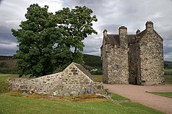
 Forter Castle | |
| Location | |
| Grid reference: | NO185649 |
| Location: | 56°46’7"N, 3°20’6"W |
| Data | |
| Post town: | Blairgowrie |
| Postcode: | PH11 |
| Dialling code: | 01575 |
| Local Government | |
| Council: | Angus |
| Parliamentary constituency: |
Angus |
Little Forter is a hamlet in Glen Isla, Angus.
The village stands on the River Isla, thirteen miles north-west of Kirriemuir and eleven miles north of Blairgowrie, on the B951 road.
References
This Angus article is a stub: help to improve Wikishire by building it up.