Stondon: Difference between revisions
Created page with "{{Infobox town |name=Stondon |county=Bedfordshire |picture=Baptist Chapel, Stondon, Beds - geograph.org.uk - 217331.jpg |picture caption=The Baptist Chapel in Lower Stondon |..." |
m clean up, typos fixed: a 13th century → a 13th-century |
||
| Line 35: | Line 35: | ||
*Baptist: Baptist chapel | *Baptist: Baptist chapel | ||
All Saints is a Victorian church with a 13th century doorway re-used from an earlier church. The font too comes from the original Norman building, built around 1150. | All Saints is a Victorian church with a 13th-century doorway re-used from an earlier church. The font too comes from the original Norman building, built around 1150. | ||
==History== | ==History== | ||
Revision as of 12:54, 27 January 2016
| Stondon | |
| Bedfordshire | |
|---|---|
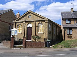
 The Baptist Chapel in Lower Stondon | |
| Location | |
| Grid reference: | TL1535 |
| Location: | 52°0’11"N, 0°19’5"W |
| Data | |
| Population: | 1,821 (2001) |
| Post town: | Henlow |
| Postcode: | SG16 |
| Dialling code: | 01462 |
| Local Government | |
| Council: | Central Bedfordshire |
| Parliamentary constituency: |
Mid Bedfordshire |
Stondon is parish and pair of villages in Bedfordshire. The parish consists of the hamlets of Lower Stondon and Upper Stondon.
The name "Stondon" derives from the Old English stan dun (or stænen dun), meaning 'Stone Hill'. The parish itself however was only created in 1985 after an amalgamation of the Lower and Upper Stondon civil parishes.[1]
The village has a golf club, a bistro, several hairdressers, a transport museum, Stondon Lower School and more.
Upper Stondon
Upper Stondon TL147356 is a hamlet, the smaller of the two, standing to the north of Lower Standon.
Lower Stondon
The larger of the two villages, though tiny still, Lower Stondon (TL155355) is to the south of its sister, on the lane leading out from the A600 and Henlow Camp. It is here that one finds the churches, the pubs, the golf club and the museum.
Lower Stondon does not have a large number of amenities; at the western end of the village there is a grocery store and post office, hairdressers and an Indian restaurant in Fakeswell Lane. Hillside Road leads to the Village Hall, Stondon Lower School, Garden Centre and Recreation Field. Another facility at the Western end of the village is the Mount Pleasant Golf Club.
The eastern end of Station Road has a BMX Track built with funds from charitable donations. Further east along Station Road is RAF Henlow and Henlow Camp, there are a number of amenities within close reach on the A600 roundabout, these consist of a grocery store, hairdressers, an estate agent, a sandwich shop, an antique shop, an electrical shop, several takeaway restaurants and a large family pub and hotel.
Churches
- Church of England: All Saints
- Baptist: Baptist chapel
All Saints is a Victorian church with a 13th-century doorway re-used from an earlier church. The font too comes from the original Norman building, built around 1150.
History
Stondon is mentioned in the Domesday Book. The entry is as follows: Standone: St Benedict's of Ramsey; Engelhere from Azelina, Ralph Tailbois' wife.
Stondon Transport Museum

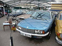
The village also hosts the largest private transport museum in the UK. The collection has over 400 exhibits, including cars, motorcycles, tanks, aircraft, and a full-size replica of Captain Cook's ship, the HM Bark Endeavour.
Outside links
| ("Wikimedia Commons" has material about Stondon) |
References
- ↑ "'Guide to Bedfordshire Parishes'". Bedfordshire.gov.uk. http://www.bedfordshire.gov.uk/CommunityAndLiving/ArchivesAndRecordOffice/GuidesToCollections/GuideToBedfordshireParishes.aspx. Retrieved 2012-08-06.
