Wellingborough: Difference between revisions
No edit summary |
|||
| Line 39: | Line 39: | ||
The manor of Wellingborough belonged to Crowland Abbey, [[Lincolnshire]], from Anglo-Saxon times and the monks probably built the original All Hallows Church.<ref>[http://crowlandabbey.org.uk/ Crowland Abbey] Retrieved 21 August 2009</ref> The mediæval town of Wellingborough housed a modest monastic grange which was a daughter house of the larger monastery of Croyland Abbey some 30 miles down-river. The site of the grange is now the Jacobean house known as Croyland Abbey. This part of the town is now known as “Croyland”. | The manor of Wellingborough belonged to Crowland Abbey, [[Lincolnshire]], from Anglo-Saxon times and the monks probably built the original All Hallows Church.<ref>[http://crowlandabbey.org.uk/ Crowland Abbey] Retrieved 21 August 2009</ref> The mediæval town of Wellingborough housed a modest monastic grange which was a daughter house of the larger monastery of Croyland Abbey some 30 miles down-river. The site of the grange is now the Jacobean house known as Croyland Abbey. This part of the town is now known as “Croyland”. | ||
Wellingborough was given a Market Charter dated 3 April 1201 when | Wellingborough was given a Market Charter dated 3 April 1201 when King John granted it to the "Abbot of Croyland and the monks serving God there" continuing, "they shall have a market at Wendligburg (Wellingborough) for one day each week that is Wednesday".<ref name="Wellingborough Market">[http://www.wellingborough.gov.uk/site/scripts/documents_info.php?documentID=123&pageNumber=1 Wellingborough Market] Retrieved 28 January 2010</ref> | ||
In the Elizabethan era the Lord of the Manor, Sir Christopher Hatton was a sponsor of Sir Francis Drake's expeditions; Drake renamed one of his ships the ''Golden Hind'' after the heraldic symbol of the Hatton family. A hotel in a Grade II listed building built in 17th century, was known variously as the Hind Hotel and later as the Golden Hind Hotel.<ref>{{cite web |title=The Golden Hind Hotel |url=http://www.imagesofengland.org.uk/Details/Default.aspx?id=233806&mode=quick |publisher=Images of England |accessdate= 26 June 2010}}</ref> | In the Elizabethan era the Lord of the Manor, Sir Christopher Hatton was a sponsor of Sir Francis Drake's expeditions; Drake renamed one of his ships the ''Golden Hind'' after the heraldic symbol of the Hatton family. A hotel in a Grade II listed building built in 17th century, was known variously as the Hind Hotel and later as the Golden Hind Hotel.<ref>{{cite web |title=The Golden Hind Hotel |url=http://www.imagesofengland.org.uk/Details/Default.aspx?id=233806&mode=quick |publisher=Images of England |accessdate= 26 June 2010}}</ref> | ||
Latest revision as of 17:27, 12 June 2017
| Wellingborough | |
| Northamptonshire | |
|---|---|
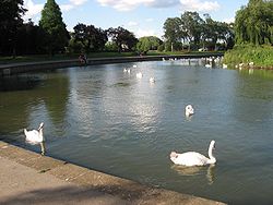 Wellingborough Embankment on the River Nene | |
| Location | |
| Grid reference: | SP8967 |
| Location: | 52°17’38"N, -0°41’47"W |
| Data | |
| Population: | 72,519 |
| Post town: | Wellingborough |
| Postcode: | NN8, NN9 |
| Dialling code: | 01933 |
| Local Government | |
| Council: | North Northamptonshire |
| Parliamentary constituency: |
Wellingborough |
Wellingborough is a market town in Northamptonshire, some 11 miles from the county town, Northampton. The town is on the north side of the River Nene. Due to the river's habit of frequent floods, the town was mostly built above the current level of the flood plain. The town is noted as a centre of high-performance engineering.
Originally named "Wendelingburgh", the town was founded in the early 6th century and is mentioned in the Domesday Book of 1086 under the name of "Wendelburie".
The town was granted a royal market charter in 1201, by King John.[1]
Geography
Geology
Wellingborough stands on the hills adjoining the flood plain of the River Nene.[2][3] In the predominantly agrarian mediæval period, this combination of access to fertile, if flood-prone, valley bottom soils and drier (but heavier and more clay-rich) hillside/ hilltop soils seems to have been good for a mixed agricultural base. The clay-rich hilltop soils are primarily a consequence of blanketing of the area with boulder clay or glacial till during the recent glaciations.[4] On the valley sides and valley floor however, these deposits have been largely washed away in the late glacial period, and in the valley bottom extensive deposits of gravels were laid down, which have largely been exploited for building aggregate in the last century.
Iron ore
The most economically important aspect of the geology of the area is the Northampton Sands ironstone formation. This is a marine sand of Jurassic age (Bajocian stage), deposited as part of an estuary sequence and overlain by a sequence of limestones and mudrocks. Significant amounts of the sand have been replaced or displaced by iron minerals giving an average ore grade of around 25 wt% iron. To the west the iron ores have been moderately exploited for a very long time, but their high phosphorus content made them difficult to smelt and produced iron of poor quality until the development of the Bessemer steel making process and the "basic slag" smelting chemistry, which combine to make high quality steelmaking possible from these unprepossessing ores. The Northampton Sands were a strategic resource for the United Kingdom as the Second World War approached, being the best developed bulk iron producing processes wholly free from dependence on imported materials. However, because the Northampton Sands share in the regional dip of all the sediments of this part of Britain to the east-south-east, they become increasingly difficult to work as one progresses east across the county.[5][6][7]
Churches
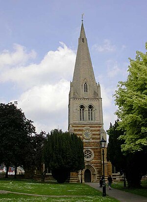
- All Hallows Church[8] is the oldest existing building in Wellingborough and dates from c. 1160. The earliest part of the building is the Anglo-Norman doorway opening in from the later south porch. The church was enlarged with more side chapels and by the end of the 13th century had assumed more or less its present plan. The west tower, crowned with a graceful broach spire rising to 160 feet, was completed about 1270, after which the chancel was rebuilt and given the east window twenty years later.[9]
- The Church of St Mary was built by Sir John Ninian Comper in the twentieth century.[10]
History
The town is believed to have been founded in the early 6th-century, its name Wendelingburgh suggesting foundation by an English leader with a name such as Wændel or his clan.[11] The town is surrounded by five wells: Red Well, Hemming Well, Witche's Well, Lady's Well and Whyte Well, which appear on the borough's arms.[12]
The manor of Wellingborough belonged to Crowland Abbey, Lincolnshire, from Anglo-Saxon times and the monks probably built the original All Hallows Church.[13] The mediæval town of Wellingborough housed a modest monastic grange which was a daughter house of the larger monastery of Croyland Abbey some 30 miles down-river. The site of the grange is now the Jacobean house known as Croyland Abbey. This part of the town is now known as “Croyland”.
Wellingborough was given a Market Charter dated 3 April 1201 when King John granted it to the "Abbot of Croyland and the monks serving God there" continuing, "they shall have a market at Wendligburg (Wellingborough) for one day each week that is Wednesday".[1]
In the Elizabethan era the Lord of the Manor, Sir Christopher Hatton was a sponsor of Sir Francis Drake's expeditions; Drake renamed one of his ships the Golden Hind after the heraldic symbol of the Hatton family. A hotel in a Grade II listed building built in 17th century, was known variously as the Hind Hotel and later as the Golden Hind Hotel.[14]
During the Civil War the largest substantial conflict in the area was the Battle of Naseby in 1645, although a minor skirmish in the town resulted in the killing of a parliamentarian officer Captain John Sawyer. Severe reprisals followed which included the carrying off to Northampton of the parish priest, Thomas Jones, and 40 prisoners by a group of Roundheads. However, after the Civil War Wellingborough was home to a colony of Diggers. Little is known about this period.
Originally the town had two railway stations. Wellingborough London Road opened in 1845 and closed in 1966. Wellingborough Midland Road (now just “Wellingborough”) is still in operation with trains to London and the Midlands towns. Since then the 'Midland Road' was dropped from the station name.[15]
Culture
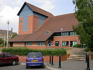
The Castle Theatre was opened in 1995 on the site of Wellingborough's old Cattle Market.[16] It brings not only a theatre to the area but other facilities for local people. Most rooms are used on a daily basis by the local community, users include the Castle Youth Theatre[17] and Youth Dance.[18]
Wellingborough has a public library in the corner of the market square.[19] The Wellingborough Museum,[20] located next door to The Castle Theatre, has exhibitions which show the past of Wellingborough and the surrounding villages. Accompanying the exhibitions and articles is a souvenir shop.[21]
Landmarks
The railway station is a Grade II Listed building, and among the many unusual and other listed buildings in Wellingborough is the 600 year old Grade I listed steeple that forms part of All Hallows Church.
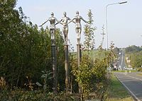
The Three Silver Ladies is one of two identical sculptures installed on the Harrowden Road, They depict local Roman history, the river, and the townspeople working together.[22]
References
- ↑ 1.0 1.1 Wellingborough Market Retrieved 28 January 2010
- ↑ Northamptonshire flood plains Retrieved 28 January 2010
- ↑ Wellingborough Geology Map
- ↑ Borough Council of Wellingborough: Northamptonshire Geology Retrieved 11 June 2010
- ↑ Northants Geology Map Retrieved 28 January 2010
- ↑ [Northamptonshire Jurassic age] Retrieved 28 January 2010
- ↑ Mike Lewis. "The Geology of Northamptonshire". Department of Geography and Geology, Northamptonshire Grammar School. http://www.brixworth.demon.co.uk/northgeo.htm. Retrieved 17 June 2010.
- ↑ All Hallows Church Retrieved 23 August 2009
- ↑ All Hallows Church: History Retrieved 26 February 2010
- ↑ Architect Design: St Mary's Wellingborough Retrieved 23 August 2009
- ↑ The Borough Council of Wellingborough: Wendel History Retrieved 28 January 2010
- ↑ Explore Northamptonshire: About Wellingborough
- ↑ Crowland Abbey Retrieved 21 August 2009
- ↑ "The Golden Hind Hotel". Images of England. http://www.imagesofengland.org.uk/Details/Default.aspx?id=233806&mode=quick. Retrieved 26 June 2010.
- ↑ Radford, B (1983). Midland Line Memories: a Pictorial History of the Midland Railway Main Line Between London (St Pancras) & Derby. London: Bloomsbury Books.
- ↑ Castle Theatre: History Retrieved 21 March 2010
- ↑ Castle Theatre: Youth theatre Retrieved 2 March 2010
- ↑ Castle Theatre: Youth dance Retrieved 2 March 2010
- ↑ Northamptonshire County Council: Wellingborough Library Retrieved 28 January 2010
- ↑ Wellingborough Museum's website Retrieved 19 June 2010
- ↑ Wellingborough Museum entry on Culture24 Retrieved 28 January 2010
- ↑ Geograph retrieved 24 June 2010
Outside links
- Northants Evening Telegraph
- BBC Northamptonshire
- Explore Northamptonshire The Official Northamptonshire tourism website