Template:FP-Ben Nevis: Difference between revisions
Jump to navigation
Jump to search
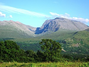
Created page with '{{#switch:{{{1}}} |pic=BenNevis2005.jpg |cap=Ben Nevis, Inverness-shire, from Banavie |text='''Ben Nevis''' is the highest mountain in the British Isles. In Scottish Gaelic i…' |
No edit summary |
||
| Line 4: | Line 4: | ||
|text='''Ben Nevis''' is the highest mountain in the [[British Isles]]. In Scottish Gaelic its name is ''Beinn Nibheis'' meaning either "venomous mountain" or "cloud-headed mountain". Ben Nevis stands at the western end of the Grampian Mountains in the Lochaber area of [[Inverness-shire]], close to the town of Fort William. | |text='''Ben Nevis''' is the highest mountain in the [[British Isles]]. In Scottish Gaelic its name is ''Beinn Nibheis'' meaning either "venomous mountain" or "cloud-headed mountain". Ben Nevis stands at the western end of the Grampian Mountains in the Lochaber area of [[Inverness-shire]], close to the town of Fort William. | ||
The mountain attracts an estimated 100,000 ascents a year. The summit, at 4,409 feet above sea level, features the ruins of an observatory, permanently staffed between 1883 and 1904.}}<noinclude> | The mountain attracts an estimated 100,000 ascents a year. The summit, at 4,409 feet above sea level, features the ruins of an observatory, permanently staffed between 1883 and 1904.}}<noinclude>{{FP data}} | ||
Latest revision as of 18:56, 5 May 2021
 |
Ben NevisBen Nevis is the highest mountain in the British Isles. In Scottish Gaelic its name is Beinn Nibheis meaning either "venomous mountain" or "cloud-headed mountain". Ben Nevis stands at the western end of the Grampian Mountains in the Lochaber area of Inverness-shire, close to the town of Fort William. The mountain attracts an estimated 100,000 ascents a year. The summit, at 4,409 feet above sea level, features the ruins of an observatory, permanently staffed between 1883 and 1904. (Read more) |