Oakwood: Difference between revisions
Jump to navigation
Jump to search
Created page with '{{Infobox town |name=Oakwood |county=Middlesex |picture=Oakwood_Baptist_Church,_Merrivale,_N14_-_geograph.org.uk_-_333654.jpg |picture caption=Oakwood_Baptist_Church,_Merrivale,_…' |
No edit summary |
||
| Line 3: | Line 3: | ||
|county=Middlesex | |county=Middlesex | ||
|picture=Oakwood_Baptist_Church,_Merrivale,_N14_-_geograph.org.uk_-_333654.jpg | |picture=Oakwood_Baptist_Church,_Merrivale,_N14_-_geograph.org.uk_-_333654.jpg | ||
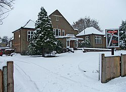
|picture caption= | |picture caption=Oakwood Baptist Church | ||
|os grid ref=TQ295955 | |os grid ref=TQ295955 | ||
|latitude=51.6433 | |latitude=51.6433 | ||
Revision as of 18:29, 3 February 2014
| Oakwood | |
| Middlesex | |
|---|---|
 Oakwood Baptist Church | |
| Location | |
| Grid reference: | TQ295955 |
| Location: | 51°38’36"N, 0°7’39"W |
| Data | |
| Post town: | London |
| Postcode: | N14 |
| Dialling code: | 020 |
| Local Government | |
| Council: | Enfield |
| Parliamentary constituency: |
Enfield Southgate |
Oakwood is an affluent village in Middlesex, at the northern edge of the Greater London conurbation. It borders Cockfosters to the west, Southgate to the south, Enfield to the east and open country to the north.

This Middlesex article is a stub: help to improve Wikishire by building it up.