North Binness Island: Difference between revisions
Created page with 'right|thumb|300px|North Binness Island at high tide '''North Binness Island''' is an island in Langstone Harbour …' |
mNo edit summary |
||
| Line 1: | Line 1: | ||
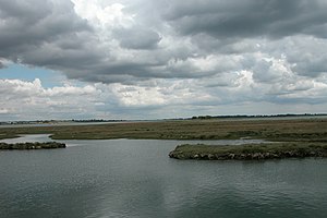
[[File:North Binness Island. - geograph.org.uk - 24740.jpg|right|thumb|300px|North Binness Island at high tide]] | [[File:North Binness Island. - geograph.org.uk - 24740.jpg|right|thumb|300px|North Binness Island at high tide]] | ||
{{county|Hampshire}} | |||
'''North Binness Island''' is an island in [[Langstone Harbour]] on the south coast of [[Hampshire]] | '''North Binness Island''' is an island in [[Langstone Harbour]] on the south coast of [[Hampshire]] | ||
The island is {{convert|900|m|yd|-1|x}} long and up to {{convert|250|m|yd|-1|x}} wide but only rises to {{convert|2.5|m|ft|0|x}} above Ordnance Datum<ref name=CBA91 /> The island was originally (along with a large part of [[Farlington Marshes]]) part of Binner's Island.<ref name=CBA87> | The island is {{convert|900|m|yd|-1|x}} long and up to {{convert|250|m|yd|-1|x}} wide but only rises to {{convert|2.5|m|ft|0|x}} above Ordnance Datum<ref name=CBA91 /> The island was originally (along with a large part of [[Farlington Marshes]]) part of Binner's Island.<ref name=CBA87>Fontana, Val and Dominic: ''Our Changing Coast a survey of the intertidal archaeology of Langstone Harbour Hampshire'', Chapter: A brief historical survey (Council for British Archaeology, 2000) ISBN 1-902771-14-1</ref> | ||
The island has been uninhabited in recent times but there is evidence of historical occupation. A | The island has been uninhabited in recent times but there is evidence of historical occupation. A 100-yard long earthwork on the island has been suggested to date from the 18th century.<ref name=CBA91 /> There is also archaeological evidence that suggests the island was occupied during the Bronze Age and the Roman period.<ref name=CBA91 /> Finds from the Bronze Age include evidence of a salt works.<ref name=Young /> The Island and has also produced finds dating back to the Mesolithic period prior to the formation of Langstone Harbour and the island.<ref name=Young>[http://ads.ahds.ac.uk/catalogue/adsdata/arch-880-1/dissemination/pdf/Hampshire_report.pdf The Aggregate Landscape of Hampshire Assessment of the Archaeological Resource] - (2008, Cornwall County Council) pages 127–128 (PDF)</ref> | ||
There was once a pond on the island, which is now filled with mud.<ref name=CBA91 /> Plants on the island consist of salt-water grasses and a few trees.<ref name=CBA91>{{cite book |last1=Adam |first1=Neil J |last2=Momber |first2=Gary |editor1-first=Michael J |editor1-last=Allen |editor2-first=Julie |editor2-last=Gardiner |title=Our Changing Coast a survey of the intertidal archaeology of Langstone Harbour Hampshire |year=2000 |publisher=Council for British Archaeology |location=York |isbn=1-902771-14-1 |pages=91–97 |chapter=North Binness Island }}</ref> | There was once a pond on the island, which is now filled with mud.<ref name=CBA91 /> Plants on the island consist of salt-water grasses and a few trees.<ref name=CBA91>{{cite book |last1=Adam |first1=Neil J |last2=Momber |first2=Gary |editor1-first=Michael J |editor1-last=Allen |editor2-first=Julie |editor2-last=Gardiner |title=Our Changing Coast a survey of the intertidal archaeology of Langstone Harbour Hampshire |year=2000 |publisher=Council for British Archaeology |location=York |isbn=1-902771-14-1 |pages=91–97 |chapter=North Binness Island }}</ref> | ||
In 1978 the island along with the other islands in Langstone Harbour was acquired by the Royal Society for the Protection of Birds who turned it into a bird sanctuary.<ref name=Tweed159 /> Since that time unauthorised landings have been forbidden.<ref name=Tweed159>{{cite book |title=A History of Langstone Harbour and its environs in the County of Hampshire |last=Tweed |first=Ronald |year=2000 |publisher=Dido Publications |isbn=0-9533312-1-0|pages=159–160 }}</ref> | In 1978 the island along with the other islands in Langstone Harbour was acquired by the Royal Society for the Protection of Birds who turned it into a bird sanctuary.<ref name=Tweed159 /> Since that time unauthorised landings have been forbidden.<ref name=Tweed159>{{cite book |title=A History of Langstone Harbour and its environs in the County of Hampshire |last=Tweed |first=Ronald |year=2000 |publisher=Dido Publications |isbn=0-9533312-1-0|pages=159–160 }}</ref> | ||
==Outside links== | |||
*Location map: {{wmap|50.837246|N|1.01793|W|region:GB_type:isle|display=title}} | |||
==References== | ==References== | ||
{{reflist}} | {{reflist}} | ||
[[Category:Islands of Hampshire]] | [[Category:Islands of Hampshire]] | ||
Revision as of 20:39, 18 July 2016

North Binness Island is an island in Langstone Harbour on the south coast of Hampshire
The island is 980 yards long and up to 270 yards wide but only rises to 8 feet above Ordnance Datum[1] The island was originally (along with a large part of Farlington Marshes) part of Binner's Island.[2]
The island has been uninhabited in recent times but there is evidence of historical occupation. A 100-yard long earthwork on the island has been suggested to date from the 18th century.[1] There is also archaeological evidence that suggests the island was occupied during the Bronze Age and the Roman period.[1] Finds from the Bronze Age include evidence of a salt works.[3] The Island and has also produced finds dating back to the Mesolithic period prior to the formation of Langstone Harbour and the island.[3]
There was once a pond on the island, which is now filled with mud.[1] Plants on the island consist of salt-water grasses and a few trees.[1]
In 1978 the island along with the other islands in Langstone Harbour was acquired by the Royal Society for the Protection of Birds who turned it into a bird sanctuary.[4] Since that time unauthorised landings have been forbidden.[4]
Outside links
References
- ↑ 1.0 1.1 1.2 1.3 1.4 Adam, Neil J; Momber, Gary (2000). "North Binness Island". in Allen, Michael J; Gardiner, Julie. Our Changing Coast a survey of the intertidal archaeology of Langstone Harbour Hampshire. York: Council for British Archaeology. pp. 91–97. ISBN 1-902771-14-1.
- ↑ Fontana, Val and Dominic: Our Changing Coast a survey of the intertidal archaeology of Langstone Harbour Hampshire, Chapter: A brief historical survey (Council for British Archaeology, 2000) ISBN 1-902771-14-1
- ↑ 3.0 3.1 The Aggregate Landscape of Hampshire Assessment of the Archaeological Resource - (2008, Cornwall County Council) pages 127–128 (PDF)
- ↑ 4.0 4.1 Tweed, Ronald (2000). A History of Langstone Harbour and its environs in the County of Hampshire. Dido Publications. pp. 159–160. ISBN 0-9533312-1-0.