Start Point, Livingston Island: Difference between revisions
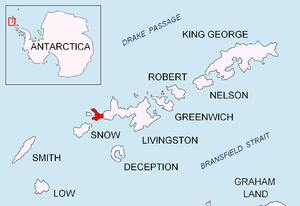
Created page with 'thumb|Location of Byers Peninsula, Livingston Island in the South Shetland Islands {{#vardefine:British Antarctic Territory}} '''Start P…' |
No edit summary |
||
| Line 14: | Line 14: | ||
* {{BATgaz}} | * {{BATgaz}} | ||
[[Category:Headlands of | [[Category:Headlands of Livingston Island]] | ||
Revision as of 12:50, 10 May 2022

Start Point is a point marking the northwest end of Byers Peninsula of Livingston Island in the South Shetland Islands, part of the British Antarctic Territory. This headland forms the southwest side of the entrance to Svishtov Cove and the northeast side of the entrance to the New Plymouth bay.
Start Point was discovered by Edward Bransfield in January 1820, and so named by him because of its resemblance to Start Point, Devon, a headland on the English Channel coast, and because the Devon coast was where his operations began.
Location
The point is located at 62°35′20″S 61°12′57.9″W / 62.58889°S 61.216083°WCoordinates: 62°35′20″S 61°12′57.9″W / 62.58889°S 61.216083°W which is 2 km southwest of Essex Point and 5 km northeast of Cape Sheffield.
Maps
- L.L. Ivanov. Antarctica: Livingston Island and Greenwich, Robert, Snow and Smith Islands. Scale 1:120000 topographic map. Troyan: Manfred Wörner Foundation, 2009. ISBN 978-954-92032-6-4