Everton, Bedfordshire: Difference between revisions
Created page with '{{Infobox town |name=Everton |county=Bedfordshire |picture= |picture caption= |os grid ref=TL201512 |latitude=52.14604 |longitude=-0.24624 |population=…' |
m Pictures |
||
| Line 2: | Line 2: | ||
|name=Everton | |name=Everton | ||
|county=Bedfordshire | |county=Bedfordshire | ||
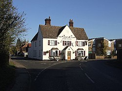
|picture= | |picture=Thornton Arms, Everton, Sandy - geograph.org.uk - 629508.jpg | ||
|picture caption= | |picture caption=The Thornton Arms, Everton | ||
|os grid ref=TL201512 | |os grid ref=TL201512 | ||
|latitude=52.14604 | |latitude=52.14604 | ||
| Line 21: | Line 21: | ||
==Parish church== | ==Parish church== | ||
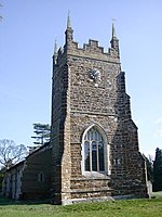
[[File:Everton church - geograph.org.uk - 131622.jpg|left|thumb|150px|St Mary's]] | |||
The parish church is St Mary's. The building is substantially of the 12th Century, though the tower, nave clerestory and south porch are 15th Century. | The parish church is St Mary's. The building is substantially of the 12th Century, though the tower, nave clerestory and south porch are 15th Century. | ||
The church is on the northern edge of the village, and just across in Huntingdonshire. | |||
==Outside links== | ==Outside links== | ||
Latest revision as of 22:17, 11 May 2012
| Everton | |
| Bedfordshire | |
|---|---|
 The Thornton Arms, Everton | |
| Location | |
| Grid reference: | TL201512 |
| Location: | 52°8’46"N, 0°14’46"W |
| Data | |
| Post town: | Sandy |
| Postcode: | SG19 |
| Dialling code: | 01767 |
| Local Government | |
| Council: | Central Bedfordshire |
| Parliamentary constituency: |
North East Bedfordshire |
Everton is a small village in northern Bedfordshire, on the very edge of Huntingdonshire. Everton has no shop but is home to a pub, The pub, the Thornton Arms, a church and a school. There is a large recreation ground which contains both full-sized and five-a-side football pitches, a basketball net, and a fenced in play area.
The southernmost part of Huntingdonshire is a detached part (only separated by a hundred yards or so from the main body of the county) encompassing part of a farm and Everton's parish church; the county boundary severing the church from the village is visible in the path immediately in front of the churchyard wall. A short track leads north to the farm gate behind. Nevertheless, the village itself is otherwise all within Bedfordshire.
Everton stand on top of Tempsford Hill on the Greensand Ridge Walk and is close to RAF Tempsford.
Parish church

The parish church is St Mary's. The building is substantially of the 12th Century, though the tower, nave clerestory and south porch are 15th Century.
The church is on the northern edge of the village, and just across in Huntingdonshire.
Outside links
| ("Wikimedia Commons" has material about Everton, Bedfordshire) |

This Bedfordshire article is a stub: help to improve Wikishire by building it up.
