Mount Richards: Difference between revisions
Created page with "{{Infobox hill |name=Mount Richards |territory=Falkland Islands |island=Saunders Island |picture=Necksaundersisland.jpg |picture caption=Mount Richards, over the Neck |latitud..." |
No edit summary |
||
| Line 10: | Line 10: | ||
|height_m=457 m | |height_m=457 m | ||
}} | }} | ||
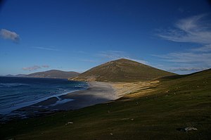
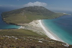
'''Mount Richards''' is the highest hill on [[Saunders Island]], one of the largest of the [[Falkland Islands]]. It stands looking down over the Neck, a narrow, sandy beach isthmus joining the main body of this unusually shaped island to its north-western extrusion. Steep slopes drop down to the sea on two sides, north and south, while its western slope rises from the Neck. | '''Mount Richards''' is the highest hill on [[Saunders Island, Falkland Islands|Saunders Island]], one of the largest of the [[Falkland Islands]]. It stands looking down over the Neck, a narrow, sandy beach isthmus joining the main body of this unusually shaped island to its north-western extrusion. Steep slopes drop down to the sea on two sides, north and south, while its western slope rises from the Neck. | ||
The hill rises to 1,499 feet above sea level and occupies the middle ground between Rookery Mountain and Mount Harston in a chain of hills running down the north coast of the island. | The hill rises to 1,499 feet above sea level and occupies the middle ground between Rookery Mountain and Mount Harston in a chain of hills running down the north coast of the island. | ||
Latest revision as of 21:28, 28 February 2021
| Mount Richards | |||
| Falkland Islands | |||
|---|---|---|---|
 Mount Richards, over the Neck | |||
| Saunders Island | |||
| Summit: | 1,499 feet 51°19’14"S, 60°12’39"W | ||
Mount Richards is the highest hill on Saunders Island, one of the largest of the Falkland Islands. It stands looking down over the Neck, a narrow, sandy beach isthmus joining the main body of this unusually shaped island to its north-western extrusion. Steep slopes drop down to the sea on two sides, north and south, while its western slope rises from the Neck.
The hill rises to 1,499 feet above sea level and occupies the middle ground between Rookery Mountain and Mount Harston in a chain of hills running down the north coast of the island.
Beneath the mountain, on the Neck, three species of penguins roost: Magellanic, Gentoo and King Penguins.[1]

Ascent
One start point for climbing the mountain is the Neck, below the mountain's western slope. Another possible staring point is a cabin known as 'Rookery Cabin' east of the hill, which can be booked as accommodation. The walk is reckoned at three and a half miles to the summit from the Neck and four and a half miles from the Rookery Cabin.[2]