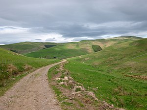
Kaim Knowe: Difference between revisions
Created page with "right|thumb|300px|Hill track by Kaim Knowe {{county|Roxburghshire}} '''Kaim Knowe''' is..." |
No edit summary |
||
| Line 17: | Line 17: | ||
*[http://www.scotlandsplaces.gov.uk/record/rcahms/281135/kaim-knowe/rcahms RCAHMS record of Kaim Knowe] | *[http://www.scotlandsplaces.gov.uk/record/rcahms/281135/kaim-knowe/rcahms RCAHMS record of Kaim Knowe] | ||
[[Category:Mountains and hills of Roxburghshire]] | |||
[[Category:Cheviot Hills]] | |||
[[Category:Hill forts in Roxburghshire]] | |||
Latest revision as of 23:17, 21 December 2016

Kaim Knowe is a hillside area at the edge of the Cheviot Hills in Roxburghshire, a mile and a half west of the ridge marking the boundary with Northumberland. The Kaim Burn runs down here, shortly to join the Bowmont Water.
- Map: NT85512000
- Location map: 55°28’25"N, 2°13’51"W
Archaeology
The significance of the place is in its archaeology. There are the earthworks of a fort with attendant village on a spur to the west and others on neighbouring hills and spurs.
On Kaim Knowe itself the remains have been found of a round-ended building of unknown date, apparently from an ancient farmstead, and the remains of stock enclosures and field boundaries have ben traced also.[1]
The structure found comprises three chambers and measures 50 feet from north-west to south-east and up to 16 feet across within the walls, themselves three feet thick.