Lauder Common: Difference between revisions
Jump to navigation
Jump to search
Created page with "Lauder Common right|thumb|300px|The cairn at the summit of Lauder Common {{county|Berwickshire}} '''Lauder Comm..." |
No edit summary |
||
| Line 1: | Line 1: | ||
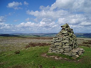
[[File:Cairn on Lauder Common - geograph.org.uk - 176240.jpg|right|thumb|300px|The cairn at the summit of Lauder Common]] | [[File:Cairn on Lauder Common - geograph.org.uk - 176240.jpg|right|thumb|300px|The cairn at the summit of Lauder Common]] | ||
{{county|Berwickshire}} | {{county|Berwickshire}} | ||
Latest revision as of 20:08, 11 November 2016

Lauder Common is an area of moorland above the village of Lauder, on the west side of Lauderdale.
The highest point on the common is 1,240 feet above sea level, and from here there are, on a clear day, spectacular views in every direction.
Location
- Location map: 55°43’12"N, 2°47’36"W
- Streetmap: NT502476