Westerdale, Caithness: Difference between revisions
Jump to navigation
Jump to search
Created page with "{{Infobox town |name=Westerdale |county=Caithness |picture=Dale Mill, Caithness - geograph.org.uk - 1635.jpg |picture caption=Dale Mill, Westerdale |os grid ref=ND128519 |lati..." |
No edit summary |
||
| Line 20: | Line 20: | ||
==Outside links== | ==Outside links== | ||
{{commons}} | {{commons|Westerdal, Highland}} | ||
[[File:Strathmore Lodge - geograph.org.uk - 157873.jpg|left|thumb|200px|Strathmore Lodge]] | |||
Latest revision as of 22:44, 14 June 2016
| Westerdale | |
| Caithness | |
|---|---|
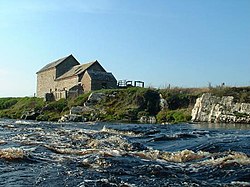
 Dale Mill, Westerdale | |
| Location | |
| Grid reference: | ND128519 |
| Location: | 58°26’49"N, 3°29’40"W |
| Data | |
| Post town: | Halkirk |
| Postcode: | KW12 6 |
| Local Government | |
| Council: | Highland |
| Parliamentary constituency: |
Caithness, Sutherland and Easter Ross |
Westerdale is a scattered crofting village in the centre of Caithness. It sits beside the River Thurso and the B870, five miles due south of Halkirk.
South of the village are the remains of a broch.
A long, dead-end lane leads out from Westerdale to Strathmore Lodge and the many lochs and lochans of the Flow Country.
Outside links
| ("Wikimedia Commons" has material about Westerdale, Caithness) |

