Church Icomb: Difference between revisions
mNo edit summary |
No edit summary |
||
| Line 10: | Line 10: | ||
|population=202 | |population=202 | ||
|census year=2011 | |census year=2011 | ||
|post town= | |post town=Cheltenham | ||
|postcode=GL54 | |postcode=GL54 | ||
|dialling code= | |dialling code= | ||
| Line 16: | Line 16: | ||
|constituency= | |constituency= | ||
}} | }} | ||
'''Church Icomb''', also known just as '''Icomb''', is a village in the [[Cotswolds]], in [[Gloucestershire]] or perhaps technically in a small, detached part of [[Worcestershire]]. Of all the scattered parcels of Worcestershire, this is the furthest flung in the south-east, seven miles form the nearest point of that county's main body. | '''Church Icomb''', also known just as '''Icomb''', is a village in the [[Cotswolds]], in [[Gloucestershire]] or perhaps technically in a small, detached part of [[Worcestershire]]. Of all the scattered parcels of Worcestershire, this is the furthest flung in the south-east, seven miles form the nearest point of that county's main body. The ancient parish of Icomb comprises the townships of Church Icomb (Worcestershire) and Westward Icomb (Gloucestershire). The civil parish was combined with that of Wick Rissington in 1935.<ref>{{cite web|url=http://visionofbritain.org.uk/unit/10381265|title=Icomb AP/CP|publisher=A Vision of Britain}}</ref> | ||
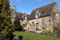
Icomb sits just four miles to the south-east of [[Stow on the Wold]] and just a mile from Gloucestershire's border with [[Oxfordshire]]. It is a place of typical, pretty Cotswold stone cottages. Its 2011 recorded population was 202. | Icomb sits just four miles to the south-east of [[Stow on the Wold]] and just a mile from Gloucestershire's border with [[Oxfordshire]]. It is a place of typical, pretty Cotswold stone cottages. Its 2011 recorded population was 202. | ||
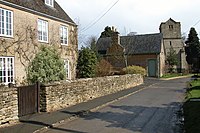
The parish church is the Church of St Mary the Virgin | The parish church is the Church of St Mary the Virgin was built in the mid 13th century. The tomb of Sir John Blaket, a knight who fought with Henry V at the Battle of Agincourt, lies within the church. | ||
==References== | ==References== | ||
{{Reflist}} | {{Reflist}} | ||
[[File:Icomb church tower viewed from the village - geograph.org.uk - 150267.jpg|left|thumb|200px|St Mary's, Church Icomb]] | |||
{{Commons}} | |||
Latest revision as of 10:51, 3 April 2019
| Church Icomb | |
| Gloucestershire, Worcestershire | |
|---|---|
 Cottages in Icomb | |
| Location | |
| Grid reference: | SP213226 |
| Location: | 51°54’7"N, 1°41’29"W |
| Data | |
| Population: | 202 (2011) |
| Post town: | Cheltenham |
| Postcode: | GL54 |
| Local Government | |
Church Icomb, also known just as Icomb, is a village in the Cotswolds, in Gloucestershire or perhaps technically in a small, detached part of Worcestershire. Of all the scattered parcels of Worcestershire, this is the furthest flung in the south-east, seven miles form the nearest point of that county's main body. The ancient parish of Icomb comprises the townships of Church Icomb (Worcestershire) and Westward Icomb (Gloucestershire). The civil parish was combined with that of Wick Rissington in 1935.[1]
Icomb sits just four miles to the south-east of Stow on the Wold and just a mile from Gloucestershire's border with Oxfordshire. It is a place of typical, pretty Cotswold stone cottages. Its 2011 recorded population was 202.
The parish church is the Church of St Mary the Virgin was built in the mid 13th century. The tomb of Sir John Blaket, a knight who fought with Henry V at the Battle of Agincourt, lies within the church.
References
- ↑ "Icomb AP/CP". A Vision of Britain. http://visionofbritain.org.uk/unit/10381265.

| ("Wikimedia Commons" has material about Church Icomb) |
