Template:FP-Carn Eige: Difference between revisions
Jump to navigation
Jump to search
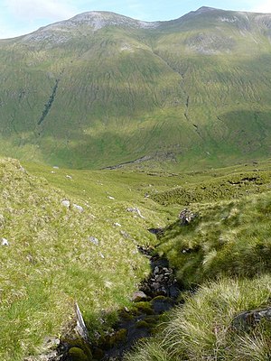
Created page with "{{#switch:{{{1}}} |pic=Steep Slopes - geograph.org.uk - 883165.jpg |cap=Carn Eige and Mam Sodhail, Ross-shire |text='''Carn Eige''', sometimes spelt '''Càrn Eighe''', is the ..." |
No edit summary |
||
| (One intermediate revision by the same user not shown) | |||
| Line 6: | Line 6: | ||
Càrn Eige is on the former lands of the Clan Chisholm. Its name is Gaelic, meaning "File hill" or "Notch hill". | Càrn Eige is on the former lands of the Clan Chisholm. Its name is Gaelic, meaning "File hill" or "Notch hill". | ||
This is a very mountain is very remote, more than 6 miles from the nearest major road, although there is a youth hostel in Glen Affric that is nearer. Its neighbour, Mam Sodhail, is just six feet shorter and the two are inevitably climbed together}}<noinclude> | This is a very mountain is very remote, more than 6 miles from the nearest major road, although there is a youth hostel in Glen Affric that is nearer. Its neighbour, Mam Sodhail, is just six feet shorter and the two are inevitably climbed together.}}<noinclude>{{FP data}} | ||
Latest revision as of 11:43, 4 May 2021
 |
Carn EigeCarn Eige, sometimes spelt Càrn Eighe, is the highest mountain north of the Great Glen, and consequently the highest mountain in Ross-shire. It stands at 3,881 feet in the midst of the Glen Affric Hills, its summit on the boundary between Inverness-shire and Ross-shire. Its height qualifies it as a 'munro'. Càrn Eige is on the former lands of the Clan Chisholm. Its name is Gaelic, meaning "File hill" or "Notch hill". This is a very mountain is very remote, more than 6 miles from the nearest major road, although there is a youth hostel in Glen Affric that is nearer. Its neighbour, Mam Sodhail, is just six feet shorter and the two are inevitably climbed together. (Read more) |