Bettws, Monmouthshire: Difference between revisions
No edit summary |
No edit summary |
||
| (One intermediate revision by the same user not shown) | |||
| Line 1: | Line 1: | ||
{{infobox town | |||
[[Category: | |county=Monmouthshire | ||
|picture=Parish church of St David's, Bettws - geograph.org.uk - 1572767.jpg | |||
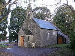
|picture caption=Parish church of St David | |||
|latitude=51.609 | |||
|longitude=-3.028 | |||
|LG district=Newport | |||
|constituency=Newport West | |||
|post town=Newport | |||
|postcode=NP20 | |||
|dialling code=01633 | |||
|os grid ref=ST289905 | |||
|population= 7,606 | |||
|census year=2011 census<ref>{{cite web|url=https://neighbourhood.statistics.gov.uk/dissemination/LeadKeyFigures.do?a=7&b=13696930&c=Bettws&d=14&e=62&g=6496934&i=1001x1003x1032x1004&m=0&r=1&s=1428173765121&enc=1|title=Newport ward 2011.Retrieved 4 April 2015}}</ref> | |||
}} | |||
'''Bettws''' is a parish that forms a suburb of the city of [[Newport, Monmouthshire|Newport]], [[Monmouthshire]]. The larger part of the parish is occupied by one of the largest modern housing estates in Europe. | |||
It is bounded by [[Malpas, Monmouthshire|Malpas]] to the east, [[Llantarnam]] to the north, [[Rogerstone]] to the west, and the [[M4 motorway]] and [[Allt-yr-yn]] to the south. | |||
The estate was built around the 17th-century St David's church, which is the likely origin of the name 'Bettws', a place of prayer or private chapel. St David's is a grade-two listed building. | |||
The housing estate was built in the 1960s, and the large majority of houses are identical in plan and design. The roads in the estate are all named after rivers. 51.8% of housing is privately owned, and 42.6% is rented from either the Newport City Council or local housing associations. | |||
In recent years it has benefited greatly from the introduction of sporting facilities such as new football pitches. Local sporting teams include Bettws RFC, Newport Civil Service F.C. and Malpas Cricket Club. | |||
==References== | |||
{{reflist}} | |||
==Outside links== | |||
{{commons category| Bettws, Newport}} | |||
*[http://www.bettws.org.uk/ Bettws Community] | |||
*[http://www.geograph.org.uk/search.php?i=6682555 Photos of Bettws, Newport and surrounding areas on geograph.org.uk] | |||
[[Category:Newport, Monmouthshire]] | |||
Latest revision as of 17:32, 19 March 2016
| Bettws, Monmouthshire | |
| Monmouthshire | |
|---|---|
 Parish church of St David | |
| Location | |
| Grid reference: | ST289905 |
| Location: | 51°36’32"N, 3°1’41"W |
| Data | |
| Population: | 7,606 (2011 census[1]) |
| Post town: | Newport |
| Postcode: | NP20 |
| Dialling code: | 01633 |
| Local Government | |
| Council: | Newport |
| Parliamentary constituency: |
Newport West |
Bettws is a parish that forms a suburb of the city of Newport, Monmouthshire. The larger part of the parish is occupied by one of the largest modern housing estates in Europe.
It is bounded by Malpas to the east, Llantarnam to the north, Rogerstone to the west, and the M4 motorway and Allt-yr-yn to the south.
The estate was built around the 17th-century St David's church, which is the likely origin of the name 'Bettws', a place of prayer or private chapel. St David's is a grade-two listed building.
The housing estate was built in the 1960s, and the large majority of houses are identical in plan and design. The roads in the estate are all named after rivers. 51.8% of housing is privately owned, and 42.6% is rented from either the Newport City Council or local housing associations.
In recent years it has benefited greatly from the introduction of sporting facilities such as new football pitches. Local sporting teams include Bettws RFC, Newport Civil Service F.C. and Malpas Cricket Club.
References
Outside links
| ("Wikimedia Commons" has material about Newport Bettws, Monmouthshire) |
