Oldbury, Worcestershire: Difference between revisions
No edit summary |
|||
| (One intermediate revision by the same user not shown) | |||
| Line 1: | Line 1: | ||
{{Infobox town | {{Infobox town | ||
|name=Oldbury | |name=Oldbury | ||
|county=Worcestershire | |county 1=Worcestershire | ||
|county 2=Shropshire | |||
|population=10,830 | |population=10,830 | ||
|picture=Warley - Sandwell Council House.jpg | |picture=Warley - Sandwell Council House.jpg | ||
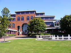
|picture caption=Sandwell Council House in Oldbury | |picture caption=Sandwell Council House in Oldbury | ||
|census year= | |census year=2001 | ||
| os grid ref=SO989897 | | os grid ref=SO989897 | ||
|latitude=52.505 | |latitude=52.505 | ||
| Line 15: | Line 16: | ||
|LG district=Sandwell | |LG district=Sandwell | ||
}} | }} | ||
'''Oldbury''' is a town in [[Worcestershire]], within the [[Black Country]] and contiguous with the surrounding towns of the Black Country conurbation. Technically it is in a detached part of [[Shropshire]] locally situate in [[Worcestershire]] (as part of the ancient parish of [[Halesowen]] granted by King Henry II to Prince Dafydd ab Owain of | '''Oldbury''' is a town in [[Worcestershire]], within the [[Black Country]] and contiguous with the surrounding towns of the Black Country conurbation. Technically it is in a detached part of [[Shropshire]] locally situate in [[Worcestershire]] (as part of the ancient parish of [[Halesowen]] granted by King Henry II to Prince Dafydd ab Owain of [[Gwynedd]] in the thirteenth century). | ||
The place name Oldbury, comes from the Old English ''Ealdenburg'', meaning "Old town" or "Old fortified place". | The place name Oldbury, comes from the Old English ''Ealdenburg'', meaning "Old town" or "Old fortified place". | ||
Latest revision as of 13:37, 20 January 2017
| Oldbury | |
| Worcestershire, Shropshire | |
|---|---|
 Sandwell Council House in Oldbury | |
| Location | |
| Grid reference: | SO989897 |
| Location: | 52°30’18"N, 2°-0’57"W |
| Data | |
| Population: | 10,830 (2001) |
| Post town: | Oldbury |
| Postcode: | B68, B69 |
| Dialling code: | 0121 |
| Local Government | |
| Council: | Sandwell |
Oldbury is a town in Worcestershire, within the Black Country and contiguous with the surrounding towns of the Black Country conurbation. Technically it is in a detached part of Shropshire locally situate in Worcestershire (as part of the ancient parish of Halesowen granted by King Henry II to Prince Dafydd ab Owain of Gwynedd in the thirteenth century).
The place name Oldbury, comes from the Old English Ealdenburg, meaning "Old town" or "Old fortified place".
The town began, as did all the towns hereabouts, as a small place, but vastly expanded in the Industrial Revolution, as industry, hungry for the coal of the South Staffordshire Coalfield, descended. Oldbury became a heavily residential town and its council in its time built several thousands houses, flats and bungalows for some 40 years until its disbandment, the 1,000th of which was completed in 1933 at Wallace Road near the border with Rowley Regis.[1]
Transport links
For over thirty years there were three railway stations in the parish named Oldbury; only one is still open, but under a new name. The oldest surviving one is on the Stour Valley Line (built by the old LMS Railway), at Bromford Road. It has been there since the 1850s. It was originally called Oldbury & Bromford Lane Station, then Oldbury Station, but it is now known as Sandwell and Dudley.
The second nearest railway station to the centre of Oldbury is at Langley Green, at Western Road, on the Stourbridge Extension Line, now the Birmingham to Worcester via Kidderminster Line. It opened in April 1867 and was originally called Langley Green & Rood End Station. However a short branch line half a mile long, the Oldbury Railway, was linked to the station with its own (third) platform. It opened in November 1884; and Langley Green & Rood End Station was then renamed Langley Green. The Oldbury Railway, which also linked to Albright and Wilson, had both a passenger station, called Oldbury, on Halesowen Road; and a goods station, Oldbury Goods railway station, at the Birmingham Canal Navigations wharf in Oldbury. Passenger services ran to Oldbury Station until March 1915; and the line closed completely other than as a freight line for Albright and Wilson. All traces of its viaduct and embankment beyond Tat Bank Road were destroyed when the M5 motorway was built.
The M5 motorway has served Oldbury since 1964 and passes the town on an elevated section built on reinforced concrete pillars. Access is from junction 2. This is also the closest junction to the Black Country Living Museum in Dudley.