Benbrake Hill: Difference between revisions
Jump to navigation
Jump to search
Created page with '{{Infobox hill |name=Benbrake Hill |range=Galloway Hills |county=Wigtownshire |picture=Quarry at Benbrake Hill - geograph.org.uk - 561323.jpg |height={{convert|312|m|ft|0|x}} |os…' |
No edit summary |
||
| (One intermediate revision by one other user not shown) | |||
| Line 4: | Line 4: | ||
|county=Wigtownshire | |county=Wigtownshire | ||
|picture=Quarry at Benbrake Hill - geograph.org.uk - 561323.jpg | |picture=Quarry at Benbrake Hill - geograph.org.uk - 561323.jpg | ||
|height= | |height=1,024 feet | ||
|latitude=55.035 | |||
|longitude=-4.7747 | |||
|os grid ref=NX227747 | |os grid ref=NX227747 | ||
}} | }} | ||
'''Benbrake Hill''' is a hill of | '''Benbrake Hill''' is a hill of 1,024 ft in [[Wigtownshire]], at the western end of the [[Galloway Hills]]. | ||
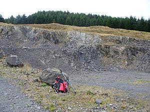
The hill is forested on its summit and its south slopes. Its wild beauty is somewhat spoilt however by quarrying. | The hill is forested on its summit and its south slopes. Its wild beauty is somewhat spoilt however by quarrying. Benbrake may be considered a twin top with Wigtownshire's [[county top]], [[Craigairie Fell]], whose summit is a mile to the south-east and which reaches 1,053 ft. | ||
Latest revision as of 15:34, 27 June 2024
| Benbrake Hill | |||
| Wigtownshire | |||
|---|---|---|---|

| |||
| Range: | Galloway Hills | ||
| Summit: | 1,024 feet NX227747 55°2’6"N, 4°46’29"W | ||
Benbrake Hill is a hill of 1,024 ft in Wigtownshire, at the western end of the Galloway Hills.
The hill is forested on its summit and its south slopes. Its wild beauty is somewhat spoilt however by quarrying. Benbrake may be considered a twin top with Wigtownshire's county top, Craigairie Fell, whose summit is a mile to the south-east and which reaches 1,053 ft.