Penpont: Difference between revisions
Created page with "{{distinguish|Penpont, Cornwall}} {{Infobox town |county=Dumfriesshire |picture= Penpont village centre - geograph.org.uk - 1326065.jpg |picture caption= Crossroads at the cen..." |
No edit summary |
||
| Line 13: | Line 13: | ||
|dialling code= 01848 | |dialling code= 01848 | ||
}} | }} | ||
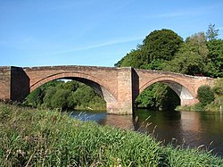
[[File:Bridge over the River Nith (3) - geograph.org.uk - 533035.jpg|thumb|250px|Bridge over the | [[File:Bridge over the River Nith (3) - geograph.org.uk - 533035.jpg|thumb|250px|Bridge over the River Nith, completed in 1778]] | ||
'''Penpont''' is a village and parish about two miles west of [[Thornhill, Dumfriesshire|Thornhill]] in [[Dumfriesshire]]. The village is near the confluence of the [[Shinnel Water]] and [[Scaur Water]] rivers in the foothills of the [[Southern Uplands]]. It has a population of about 400 people. The parish extends to the border with [[Kirkcudbrightshire]]. | '''Penpont''' is a village and parish about two miles west of [[Thornhill, Dumfriesshire|Thornhill]] in [[Dumfriesshire]]. The village is near the confluence of the [[Shinnel Water]] and [[Scaur Water]] rivers in the foothills of the [[Southern Uplands]]. It has a population of about 400 people. The parish extends to the border with [[Kirkcudbrightshire]]. | ||
| Line 20: | Line 20: | ||
==History== | ==History== | ||
The toponym ''Penpont'' means "bridge-head" in the Cumbric language once spoken in the region.<ref>{{Cite journal |last=Watson |first=William J |year=1925 |title=The Celts (British and Gael) in Dumfriesshire and Galloway |journal=Transactions and Journal of Proceedings of the Dumfriesshire and Galloway Natural History and Antiquarian Society |series=Third Series |volume=XI |page=147 |url=http://www.dgnhas.org.uk/transonline/SerIII-Vol11.pdf#page=153 | | The toponym ''Penpont'' means "bridge-head" in the Cumbric language once spoken in the region.<ref>{{Cite journal |last=Watson |first=William J |year=1925 |title=The Celts (British and Gael) in Dumfriesshire and Galloway |journal=Transactions and Journal of Proceedings of the Dumfriesshire and Galloway Natural History and Antiquarian Society |series=Third Series |volume=XI |page=147 |url=http://www.dgnhas.org.uk/transonline/SerIII-Vol11.pdf#page=153 |access-date= |archive-url=http://web.archive.org/web/20140831051704/http://www.dgnhas.org.uk/transonline/SerIII-Vol11.pdf |archive-date=31 August 2014}}</ref> | ||
The A702 road passes through Penpont. West of Thornhill it crosses the [[River Nith]] on a two-arched stone bridge in Penpont parish. It wsa built in the 1760s after the presbytery of Penpont raised £680 toward the cost. Work started about 1774, but in 1776 the bridge collapsed. The bridge was completed in 1778 and strengthened in 1930–31. It is a Category A listed building.<ref>{{cite web |url= http://data.historic-scotland.gov.uk/pls/htmldb/f?p=2200:15:0::::BUILDING:17286 |title=Nith Bridge (A702 over River Nith) |publisher=[[Historic Scotland]] |date=3 August 1971 |accessdate=15 June 2015}}</ref> | The A702 road passes through Penpont. West of Thornhill it crosses the [[River Nith]] on a two-arched stone bridge in Penpont parish. It wsa built in the 1760s after the presbytery of Penpont raised £680 toward the cost. Work started about 1774, but in 1776 the bridge collapsed. The bridge was completed in 1778 and strengthened in 1930–31. It is a Category A listed building.<ref>{{cite web |url= http://data.historic-scotland.gov.uk/pls/htmldb/f?p=2200:15:0::::BUILDING:17286 |title=Nith Bridge (A702 over River Nith) |publisher=[[Historic Scotland]] |date=3 August 1971 |accessdate=15 June 2015}}</ref> | ||
Latest revision as of 15:23, 18 May 2024
- Not to be confused with Penpont, Cornwall
| Penpont | |
| Dumfriesshire | |
|---|---|
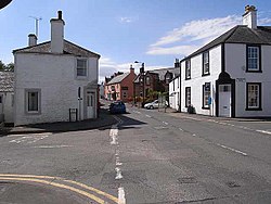
 Crossroads at the centre of Penpont | |
| Location | |
| Grid reference: | NX8494 |
| Location: | 55°13’55"N, 3°48’54"W |
| Data | |
| Post town: | Thornhill |
| Postcode: | DG3 |
| Dialling code: | 01848 |
| Local Government | |
| Council: | Dumfries and Galloway |
| Parliamentary constituency: |
Dumfriesshire, Clydesdale and Tweeddale |

Penpont is a village and parish about two miles west of Thornhill in Dumfriesshire. The village is near the confluence of the Shinnel Water and Scaur Water rivers in the foothills of the Southern Uplands. It has a population of about 400 people. The parish extends to the border with Kirkcudbrightshire.
Archaeology
There are several archaeological sites nearby, including Late Bronze Age hill forts on Tynron Doon[1] and Grennan Hill and a long cairn at Capenoch Loch[2] dating from the 2nd or 3rd century.
History
The toponym Penpont means "bridge-head" in the Cumbric language once spoken in the region.[3]
The A702 road passes through Penpont. West of Thornhill it crosses the River Nith on a two-arched stone bridge in Penpont parish. It wsa built in the 1760s after the presbytery of Penpont raised £680 toward the cost. Work started about 1774, but in 1776 the bridge collapsed. The bridge was completed in 1778 and strengthened in 1930–31. It is a Category A listed building.[4]
Penpont's Church of Scotland parish church is a Gothic Revival building completed in 1867. It is a Category B listed building.[5] It has an Art Nouveau Communion table made in 1923.
Penpont's war memorial was made by Glasgow sculptor William Kellock Brown and installed in 1920. It is a bronze statue of an infantryman, with his rifle pointing downwards, his hands resting on the butt and his head slightly bowed.
Notable people
Joseph Thomson (1858–95), the geologist and explorer after whom Thomson's Gazelle is named, was born in Penpont.
The sculptor Andy Goldsworthy[6] has lived in the village since 1986 and has a workshop there. Many of his works are in the surrounding countryside, including a pinecone-shaped sculpture at Stepends Farm made to celebrate the year 2000. Each year Penpont holds a week-long festival called the Penpont Gala,[7] beginning in the first week of July.
References
- ↑ "Views around the top of Tynron Doon". Cairnsmore of Carsphairn and the Scaur Hills. South West Scotland Hill Walking Routes. http://www.walkscotland.plus.com/scaur/glen_w/tynd/pages/01.html.
- ↑ "Capenoch Loch (Cairn(s))". The Modern Antiquarian. Julian Cope. http://www.themodernantiquarian.com/site/6665/capenoch_loch.html.
- ↑ Watson, William J (1925). "The Celts (British and Gael) in Dumfriesshire and Galloway". Transactions and Journal of Proceedings of the Dumfriesshire and Galloway Natural History and Antiquarian Society. Third Series XI: 147. http://www.dgnhas.org.uk/transonline/SerIII-Vol11.pdf#page=153.
- ↑ "Nith Bridge (A702 over River Nith)". Historic Scotland. 3 August 1971. http://data.historic-scotland.gov.uk/pls/htmldb/f?p=2200:15:0::::BUILDING:17286. Retrieved 15 June 2015.
- ↑ "Penpont Village Penpont Church and Churchyard". Historic Scotland. 26 June 1986. http://data.historic-scotland.gov.uk/pls/htmldb/f?p=2200:15:0::::BUILDING:17267. Retrieved 15 June 2015.
- ↑ "Andy Goldsworthy Archive". Andy Goldsworthy Digital Catalogue. http://www.goldsworthy.cc.gla.ac.uk/archive/.
- ↑ http://chrisfrear.photium.com/portfolio34657.html
Outside links
| ("Wikimedia Commons" has material about Penpont) |
This Dumfriesshire article is a stub: help to improve Wikishire by building it up.
