Difference between revisions of "Castlederg Castle"
From Wikishire
(Created page with "{{Infobox castle |name=Castlederg Castle |county=Tyrone |picture=Castlederg Castle - geograph.org.uk - 3046896.jpg |picture caption= |os grid ref=H26058442 |latitude=54.707299...") |
|||
| Line 14: | Line 14: | ||
|website= | |website= | ||
}} | }} | ||
| − | '''Castlederg Castle'' stands in ruin above [[Castlederg]] in [[Tyrone]]. It is set in a strategic position, on a low hummock surrounded on three sides by boggy ground and on south by the River Derg. | + | '''Castlederg Castle''' stands in ruin above [[Castlederg]] in [[Tyrone]]. It is set in a strategic position, on a low hummock surrounded on three sides by boggy ground and on south by the River Derg. |
| − | In 1622, the castle was described as "a bawne of stone & lyme, not finished, being 100ft long, 80ft broad & 5ft high, with 3 open Flankers of the same height..". The north wall and two square corner turrets survive in ruined state, while of the other walls only foundations remain. | + | In 1622, the castle was described as: |
| + | |||
| + | {{quote|"a bawne of stone & lyme, not finished, being 100ft long, 80ft broad & 5ft high, with 3 open Flankers of the same height..".}} | ||
| + | |||
| + | The north wall and two square corner turrets survive in ruined state, while of the other walls only foundations remain. | ||
Excavations revealed at least four phases of activity on the site, starting before the castle itself was built. | Excavations revealed at least four phases of activity on the site, starting before the castle itself was built. | ||
| Line 22: | Line 26: | ||
==References== | ==References== | ||
*[https://apps.communities-ni.gov.uk/NISMR-PUBLIC/Details.aspx?MonID=14212 Castlederg Castle]: Monument Record | *[https://apps.communities-ni.gov.uk/NISMR-PUBLIC/Details.aspx?MonID=14212 Castlederg Castle]: Monument Record | ||
| + | [[File:Castlederg Castle - geograph.org.uk - 3003285.jpg|left|250px|Castlederg Castle]] | ||
Latest revision as of 22:46, 7 December 2022
| Castlederg Castle | |
|
Tyrone | |
|---|---|

| |
| Location | |
| Grid reference: | H26058442 |
| Location: | 54°42’26"N, 7°35’48"W |
| Village: | Castlederg |
| History | |
| Information | |
| Condition: | Ruined |
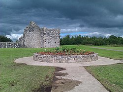
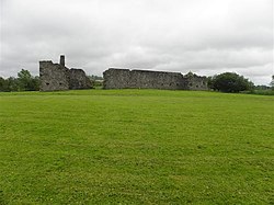
Castlederg Castle stands in ruin above Castlederg in Tyrone. It is set in a strategic position, on a low hummock surrounded on three sides by boggy ground and on south by the River Derg.
In 1622, the castle was described as:
"a bawne of stone & lyme, not finished, being 100ft long, 80ft broad & 5ft high, with 3 open Flankers of the same height..".
The north wall and two square corner turrets survive in ruined state, while of the other walls only foundations remain.
Excavations revealed at least four phases of activity on the site, starting before the castle itself was built.
References
- Castlederg Castle: Monument Record
